Last Updated on 23 December 2025 by Cycloscope
Cycling Albania: Our Trip Through the Albanian Alps – From Tirana to Shkodër, Tamarë, and Lepushë, Including Komani Lake and the Valbona–Theth Hiking Trail
In this article:
- Ferries to Albania + Other Bike-Friendly Transportation Options
- Internet, currency, and payments: practical tips
- From Durrës to Tirana: traffic and the bus with bikes
- Tirana: a vibrant capital of colors, modern architecture, and bike lanes
- Velipoja Protected Landscape and the Rana e Hedhun dunes
- Shköder to Valbona – Theth Hiking Trail + Komani Lake ferry
- The Albanian Alps: from Shkodër to Tamarë
- Tamarë to Selcë + Montenegro Border
Ferries to Albania + Other Bike-Friendly Transportation Options
Disclosure: Some of our articles contain affiliate links. This comes at no additional cost for you and helps us keep this website up and running. (as Amazon Associates we earn commission from qualifying purchases)

We arrived in Albania by sea, opting for the ferry from Bari to Durrës – a comfortable and scenic choice that turns the journey into a real adventure highlight. There are daily routes from Brindisi to Vlorë and Ancona to Durrës as well, with frequent departures year-round.
We sailed at 10 PM and docked early the next morning in Durrës port, paying around €60 per person (including an internal cabin with a hot shower). Prices increase during high season, but it’s still a great value.
If you’re leaving from Bari like us, heads up: check-in is about 3 km from the boarding point – a frustrating detail, especially cycling on dark roads full of trucks. We arrived early to avoid stress. At Durrës, everything was quick and smooth, taking only minutes.
For us, the ferry is the best option when traveling with bikes: no disassembly or complicated packing – just roll them on board! Alternatives include low-cost flights to Tirana or FlixBus services that often allow bikes (book via app, though availability can be spotty in winter).
Ferry Routes and Companies from Italy to Albania
Main connections run year-round, with more sailings in summer (check Ferryhopper or Direct Ferries for 2025/2026 updates):
Bari – Durrës (~8-10 hours, often overnight):
- Several daily departures.
- Companies: GNV, Adria Ferries, Ventouris Ferries.
- Prices: from ~€50-60/person; bikes/vehicles welcome.
Brindisi – Vlorë (~5-8 hours):
- Up to 3 daily in peak season.
- Companies: Star Lines, A-Ships Management, European Seaways.
- Prices: from ~€35-55/person. Ideal for the Albanian Riviera.
Ancona – Durrës (~16-19 hours):
- Weekly departures.
- Company: Mainly Adria Ferries.
- Prices: from ~€80-100.
All accept bikes, vehicles, and pets. Check Directferries.com to compare companies. We took Ventouris line from Bari to Albania, and GNV on the way back. We can say Grimaldi is a bit better.
Internet, currency, and payments: practical tips
I recommend buying a SIM card as soon as you arrive; you’ll find a shop right at the port exit if you arrive by ferry.
Internet in Albania is expensive, but Wi-Fi is available almost everywhere—from cafés to hotels—and works very well.
Since we weren’t camping, the SIM card was essential for searching for places to stay and contacting them to book. We chose an unlimited plan for €30 (valid for 21 days), which works throughout the Balkans.
Almost everywhere in Albania, you pay in cash (except in supermarkets), including for the SIM card at the port (where the exchange rate is the worst in the country!).
ATMs are available in the main cities, but check the fees carefully: they often add high commissions, and your bank’s exchange rate is never favorable.
Withdrawals usually start with a fixed fee of €8–10, plus an unfavorable exchange rate, so you could end up paying €20 in fees to withdraw €100.
Bring euros in cash (they’re accepted everywhere, even coins). Hotels and B&Bs quote prices in euros: an apartment with a kitchen costs around €20–30.
The exchange rate used almost everywhere is €1 = 100 lek, so they will charge you 2,000, while the official rate is around 96–97 lek per euro. Paying in lek using this conversion means you always lose money.
From Durrës to Tirana: traffic and the bus with bikes
Traffic between Durrës and Tirana is heavy, with a chaotic main road. There is a parallel secondary road, but it doesn’t cover the entire route. Near the port of Durrës, there is the bus station, with hourly departures to Tirana.
We chose the bus (€10 per person, bikes loaded without any issues) — easy and relaxing. If the bus is full of luggage, you might have to wait for the next one, but it never happened to us. Watching the road from the window, we didn’t regret our choice at all!
Tirana’s bus station is about 4 km from the city center, with terrible traffic on arrival. But once you get close to the heart of the city, here comes the surprise: a network of bike lanes welcomes you and takes you everywhere!
Tirana: a vibrant capital of colors, modern architecture, and bike lanes
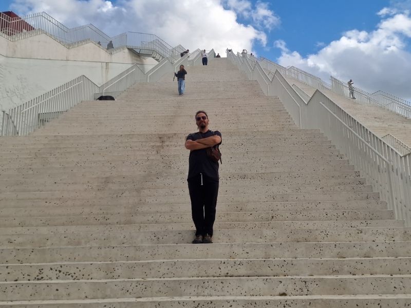
Tirana won us over immediately: chaotic yet fascinating, with a unique mix of communist past and contemporary rebirth. As soon as you enter the city center, bike lanes guide you safely through the city—a true paradise for those traveling by bicycle! The network is constantly expanding, with dedicated routes separated from traffic, perfect for stress-free exploration.
The beating heart is Skanderbeg Square, huge and pedestrian-only, surrounded by historic buildings such as the Et’hem Bey Mosque and the National History Museum.
From here, get lost in the Blloku district, once reserved for the communist elite, now the city’s trendiest area with stylish cafés, street art, fusion restaurants, and a lively nightlife.
What makes Tirana truly unique is its colorful and innovative architecture. The former mayor (now prime minister) Edi Rama, an artist by training, transformed the gray post-communist city by painting buildings in vivid colors—reds, yellows, blues, geometric patterns that lift the mood and symbolize rebirth. Walking or cycling around, you’ll encounter rainbow façades that make every corner photogenic.
In recent years, Tirana has experienced a boom in modern architecture: bold skyscrapers like Downtown One, the “Eyes of Tirana,” and other high-rises around Skanderbeg Square and the New Boulevard.
The Pyramid (former Hoxha museum) has been renovated into a cultural center, a perfect symbol of this evolution.
Don’t miss the Grand Park with its artificial lake for a green break, but skip the bunkers turned into museums (Bunk’Art).
Velipoja Protected Landscape and the Rana e Hedhun dunes
From Tirana, we head north toward Shkodër, the number of dental clinics shows no sign of slowing down—Albania has become a popular destination for those seeking affordable dental care.
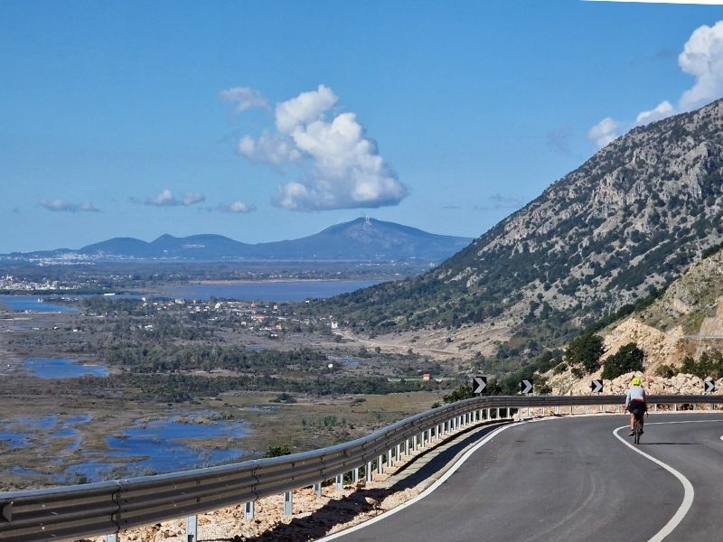
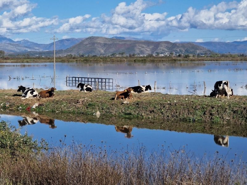
Then we explored the Buna River – Velipoja Protected Landscape, a vast natural area where river, lagoon, forest, and sea meet. The Buna River (shared with Montenegro) flows gently through wetlands rich in birdlife before reaching the Adriatic, creating a calm, scenic corridor ideal for cycling, walking, and nature watching.
Following the coast southward, the landscape leads to Rana e Hedhun (meaning “Thrown Sand” in Albanian), a striking natural monument near Shëngjin.
This unique beach is famous for its towering golden dunes—among the largest in the Balkans—that plunge directly into the clear Adriatic Sea.
Shkodër is a nice but nothing special town. We found a room for €15 in a hostel near the pedestrian area.
It has a garden and a garage for our bikes, which we leave there for a couple of days while we go on the famous Valbona–Theth Hiking Trail. The last ferry of the season runs on November 5, before the winter closure.
Shköder to Valbona – Theth Hiking Trail + Komani Lake ferry
Day 1. Shköder to Valbona + Komani Lake Ferry
- 6:45 Bus to the Ferry
- 11:00 Ferry (2.5 hrs)
- 12:30 Bus to Valbona
- 14:00 Arrive at Valbona
We paid €20 each for all the transfers, booking directly through the website of one of the main companies that organizes them: Komani Lake Ferry (komanilakeferry.com), where you can book ferry and combined transport tickets online.
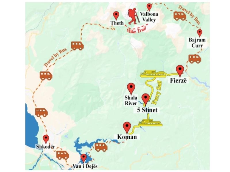
The ferry route is wonderful. During the summer season, some ferries transport cars, motorcycles, bicycles, and passengers — you can always bring your bike.
The scenic route across Lake Koman is about 2–2.5 hours long, with breathtaking views of steep gorges and turquoise water, often compared to fjords.
On our ferry, there was a group of cyclists and also four motorcyclists whose bikes were loaded — not without some difficulty — on the sides of the ferry.
The entire journey is spectacular: you watch the gorge with vertical drops and observe the life of people living along the water.
Several times, the boat stops to load and unload locals waiting on rocks or stepping into what seems like nowhere. From the map, there are many trails — some drivable — leading to small clusters of houses and farms along the way.
On one occasion, we even stopped to bring two cold beers to locals waiting on a rock! The ferry is small, it has a bathroom, and there’s a fridge on board if you want to have a beer during the trip.
The ferry stops at Fierza, where there is a bar/restaurant and little else. From there, the minibus picks you up and takes you to Valbona.
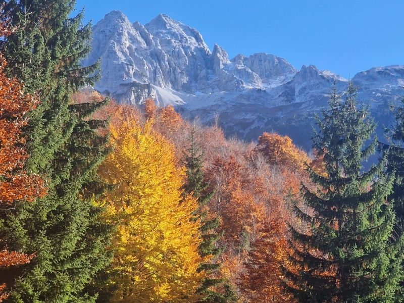
The road to Valbona is beautiful, and I highly recommend traveling it in autumn, when the colors — bright yellow, orange, and red — are incredible.
Day 2. Valbona – Theth Hiking

- 7:30 Breakfast
- 8:00 starts the hike
- Hike (8 hrs)
- Arrive at Theth
At Valbona, there isn’t much to do — it’s not a real town, just a scattered collection of houses offering places to sleep. We chose a hotel (Hotel Margjeka), one of the closest to the start of the trail.
The minibus drops every tourist off at their accommodation. If your guesthouse is farther away, the next morning there’s a minibus service that takes you to the beginning of the trails.
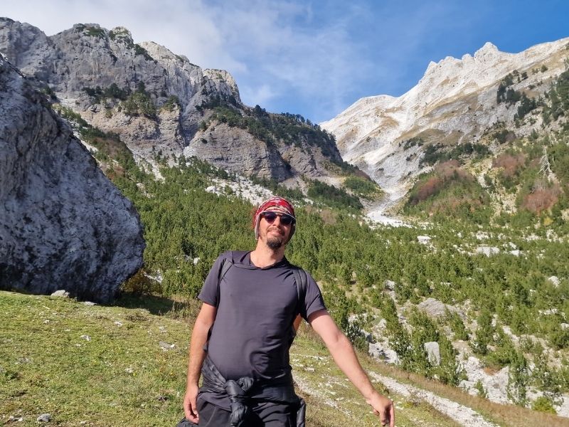
Our hotel had a wonderful view of the Albanian Alps and an excellent restaurant.
Breakfast was included and served from 7:30 a.m., though we would have liked to leave earlier. Since we were there in late October, the days were short — it was dark by 4 p.m.
Hotels and guesthouses in Valbona prepare packed lunches for hikers. There are a couple of bars along the road, but in this season, they were either closed or serving only drinks.
Anyway, there were some tourists around, so you’re never truly “alone,” but at the same time, you’re in total peace. From what we heard, in the summer, the trail can be very busy.
The route is well marked, but I still recommend downloading an offline map of the trail — it’s available on Komoot and other apps.
Two people on our minibus, whom we met again at the end of the trail, got lost — they had started on the wrong path and arrived more than an hour after sunset. Fortunately, it was a sunny day.
We hiked with an English couple from our hotel — if you’re alone, it’s often better to join someone. We ended up seeing everyone from our minibus along the way.
After a couple of kilometers following the riverbed, you reach the start of the real trail, which then climbs up to about 1,800 m.
The views of the Albanian Alps along the route are truly spectacular — rugged peaks, deep valleys, and dramatic mountain landscapes that are especially vivid in autumn.
As you climb, the autumn colors fade; the trees are already bare, and the thick layer of leaves on the trail can be slippery. Going up from Valbona is less steep than hiking it in the opposite direction.
The descent toward Theth is more forested with fewer epic viewpoints. We took about 8 hours, with stops for photos and food, but it didn’t feel rushed. The descent took longer than expected — perhaps because our knees weren’t cooperating so well.
Day 3. Theth to Shköder
- Explore Theth
- 11:00 Bus to Shköder
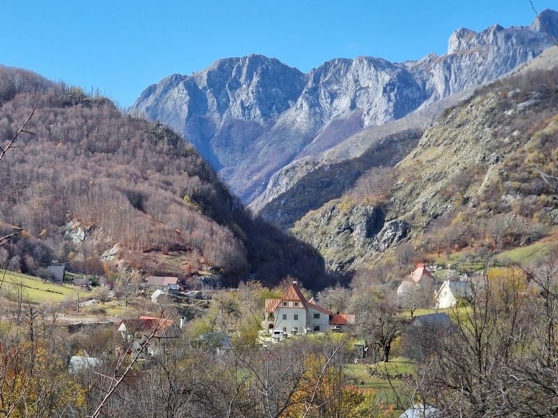
The village of Theth is still developing — hotels and guesthouses are being built everywhere, and many tourists, especially locals, visit in summer. The road ends in Theth.
We stayed in a very nice guesthouse, but it was somewhat overpriced for Albanian standards, at about €35. From Theth, there are several hiking trails nearby, including the most famous one that leads to the Blue Eye (Syri i Kaltër), a stunning natural spring with crystal‑clear water.
The area also offers other shorter trails around the village and along the riverside, as well as a route to Grunas Waterfall, allowing for a day full of hiking and exploring if you wish to spend an extra day in the region.
The next morning at 11:00, our minibus departed to take us back to Shkodër. The road to Shkodër is pleasant, though not as dramatic as the one that brought us to Valbona.
The Albanian Alps: from Shkodër to Tamarë
From Shkodër, we set off toward Koplik. The road is moderately busy but has a side lane suitable for cycling, and the first 25 km are flat, making it easy to leave the city behind.
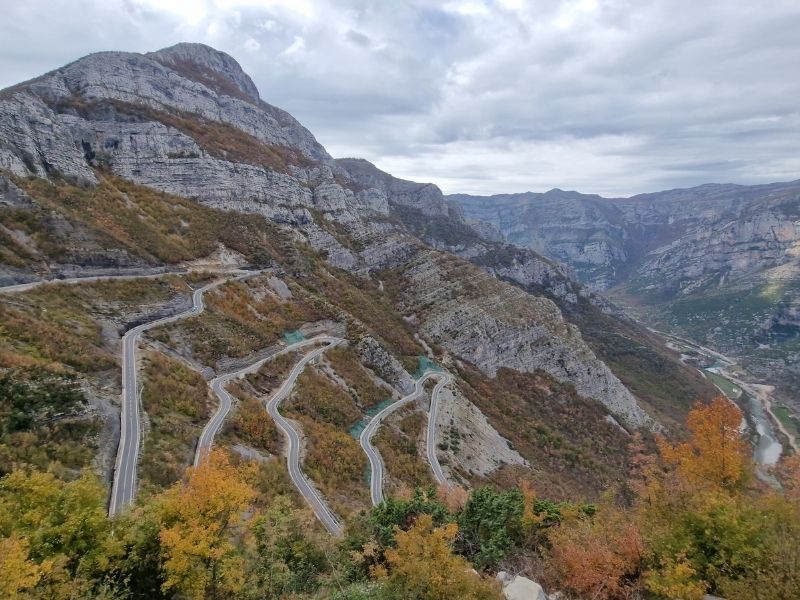
Beyond Koplik, the route climbs gradually toward Hot, leading to a series of hairpin bends that take us up to approximately 600 meters above sea level.
The panorama is spectacular, and to our delight, at the top there’s even a sandwich truck, offering a quick snack and a beer before the steep descent into the valley below.
The road then winds along the Cemi River, and we reach Tamarë, a small tourist village at 200 meters above sea level, nestled between the mountains.
The village marks the end of the road, with a handful of guesthouses and small accommodations. Here we try Albanian polenta, which we absolutely loved, while enjoying the peaceful mountain setting.
Tamarë to Selcë + Montenegro Border
The next day, the road continues to climb, always following the river, until we reach Selcë, a larger village but still with only a couple of guesthouses. We are forced to stop here because it starts to rain heavily.
From the village of Selcë, there are multiday hikes that we would really like to do — for example, the classic trail from Selcë to Vermosh Pass, which follows ancient paths between traditional mountain villages, crosses deep valleys and forests, and offers a true backcountry experience through the Albanian Alps, but certainly not in this season due to weather and wet conditions.
We stayed in Turi‑Selcë Guesthouse, a welcoming local guesthouse where the owners prepared us the best meals we have had in Albania so far. We tried the local stuffed eggplant dish known as Imam Bajalldi (literally “the imam fainted”), and absolutely loved it.
The next morning at 11:00, we are ready to tackle the rest of the climb, which will take us up again to about 1,900 meters above sea level. It isn’t raining, but the headwind is extremely strong, and at times we have to get off and push our bikes. If needed, there are guesthouses in a couple of villages along the way — you can find them easily on Google Maps.
We finally reach the top, where an elderly man runs a small bar that he shares with his cat and a wood‑burning stove. We drink a hot coffee and then begin the descent.
It’s about to snow, and the temperature is around ‑2 °C. The descent takes us to the border with Montenegro, and from there we will continue toward Kosovo, Macedonia, and eventually back into Albania, heading for Greece. Our article about the full trip in the Balkans can be read here.
This trip actually started from Rome; you can have a look at our article about Cycling Italy Coast to Coast. If you are in love with Alpine Landscape, have a look at:
- Alpe Adria Cycle Trail – Hints, itinerary, map, gps tracks, and sights
- The most beautiful greenways along former railway lines in Italy
- Japanese Alps, Shirakawa Go, a Leap Into Traditional Japan
- Spiti Valley Bikepacking Tour – Shimla to Kaza + Kunzum Pass
- Our Manali Leh Bicycle Trip – All You Need To Know – UP TO DATE