Last Updated on 13 December 2025 by Cycloscope

Italy’s most beautiful cycling paths created from abandoned railway lines: scenic routes through nature and historic villages, perfect for cycle tourists of all levels
The network of cycling routes in Italy, as in the rest of Europe, is expanding more and more.
Disclosure: Some of our articles contain affiliate links. This comes at no additional cost for you and helps us keep this website up and running. (as Amazon Associates we earn commission from qualifying purchases)

As many of us have experienced firsthand, these are not always true, purpose-built cycling paths, but often regular roads—sometimes lightly trafficked (and sometimes very busy)—that are simply labeled as a “cycle tourism route.”
Just a few weeks ago, while cycling from Matera to Metaponto and following the signs for the “cycle route,” we found ourselves riding along a main state road for at least 20 kilometers.
The routes described here, most of which we have personally ridden, are instead true greenways: protected paths dedicated to slow mobility, designed to connect natural, urban, or rural areas without any interference from motorized traffic.
Although they are far more developed in northern Italy, the south also offers beautiful cycling routes along abandoned railway lines—still little known and therefore wonderfully authentic.
Greenways in Italy
- Fiuggi–Paliano Cycle Path (Lazio)
- Alpe Adria Cycle Route (Friuli)
- Spoleto–Norcia Cycle Path (Umbria)
- Dolomites Cycle Path (Veneto & South Tyrol)
- Anapo Valley Cycle Path (Sicily)
- Pollino Cycle Route (Basilicata – Calabria)
Fiuggi–Paliano Cycle Path (Lazio)

We actually started from the town of Colleferro, near Rome. If you’re in the capital, you can take a train that allows bicycles on board for free, making it easy to escape city traffic. From Colleferro, we took the Palianese road toward the cycle path connecting Paliano to Fiuggi.
Although not very well known, this cycle path is one of the most scenic in Lazio, also because it follows the route of the historic Rome–Fiuggi–Alatri–Frosinone railway, a narrow-gauge line inaugurated in the early 1900s.
Today, the tracks are gone: in their place runs a greenway, surrounded by nature—wide, smooth, and with gentle gradients, thanks to its railway origins.
The route does not pass through towns, making it perfect for those who love cycling in silence, among fields, small woodlands, and views over the Sacco Valley. The full route is available on Komoot.
We rode this cycle path during our journey from the Tyrrhenian Sea to the Adriatic, and then on toward the Balkans. Here you can download the GPX track of the route.
Alpe Adria Cycle Route (Friuli)
The Alpe Adria Cycle Route is part of the long-distance cycling itinerary that connects Salzburg, Austria, to Grado, in the Friuli region of Italy.
The Italian section of the route starts at the Austrian border and is 175 kilometers long, taking you from the Carnic Alps to the Julian Alps and finally to the Adriatic Sea—a journey that will amaze you with its epic landscapes.
The entire Italian route stays within the Friuli Venezia Giulia region.
While the Austrian section of the route is quite demanding, reaching Little Ankogel at 2,400 meters above sea level, the Italian part of the cycle path is mostly fairly easy. This makes it an excellent cycling holiday even for families, while more experienced cyclists can also ride it as a long day trip.
The Alpe Adria Cycle Route is fully paved and, for most of its length, reserved exclusively for bicycles. In fact, the route follows the track of a former railway dating back to the late 19th century, which once connected Vienna to Venice.
You can download the GPX track of the entire route at this link: Alpe Adria Cycle Route.
You can read all the details about the Italian section of the Alpe Adria Cycle Route in our dedicated article on this beautiful itinerary.
Spoleto–Norcia Cycle Path (Umbria)
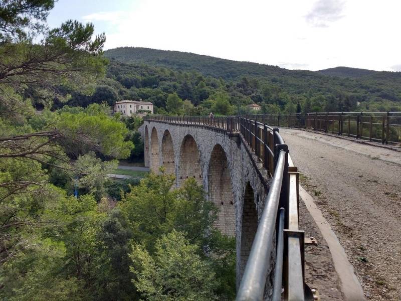
The Spoleto–Norcia Cycle Route is an itinerary deeply rooted in the history of a legendary railway. Opened in 1926 and closed in the 1960s, the Spoleto–Norcia line was considered a masterpiece of engineering.
Gentle gradients, wide curves, daring viaducts, and spiral tunnels allowed trains to climb the Apennines without ever exceeding a 4.5% gradient.
Today, that route—reclaimed by nature and given back to slow travelers—has become one of the most thrilling cycle paths in Europe.
The itinerary begins just outside Spoleto. The first kilometers wind through dense forests, streams, and small bridges, while the climb—always steady and never excessive—gradually leads cyclists into the mountains.
From here, a series of tunnels follows. The most famous, the Caprareccia spiral tunnel, allows the route to gain elevation in a perfect spiral, creating the sensation of being inside the heart of the mountain.
After the most demanding section, you reach Sant’Anatolia di Narco and its surroundings, dotted with Romanesque abbeys. Here, the former railway line now runs along the valley floor, alongside the Nera River.
From this point, the cycle route continues with a gentler profile, crossing stone bridges, passing former stations converted into refreshment stops, and unfolding through landscapes that alternate between forests, gorges, and grassy plateaus. At every turn, traces of the railway emerge—from the parapets of viaducts to the still-intact tunnel portals.
The approach to Norcia is a gradual transition into a widening valley after so many sections carved into the mountainside, revealing a broader, brighter landscape. The cycle route ends just outside the historic center. Here you can download the GPX track.
Dolomites Cycle Path (Veneto & South Tyrol)

The Dolomites Cycle Route, which connects Cortina d’Ampezzo to Dobbiaco, stretches for about thirty kilometers along what was once the Dolomites railway, a narrow-gauge line inaugurated in the 1920s and permanently closed in the 1960s.
The route starts in Cortina, surrounded by the towering Tofane, and immediately leads into a bright and silent natural landscape.
Old stations, now converted into cafés, rest stops, or simple architectural reminders, punctuate the journey, while the path mostly runs on a compact surface suitable for all types of cyclists.
The climb is steady but never challenging, thanks to the gentle railway gradients, gradually leading to the Cimabanche Pass, the highest point of the route and the border between Veneto and South Tyrol.
From here, the path gently descends toward Dobbiaco, offering one of the most spectacular sections: forests of fir and larch trees, bridges over small streams, and, above all, the feeling of traveling through the heart of the authentic Dolomites.
The view over the Landro area is one of the highlights of the entire route. In this section, you can also spot the famous viewpoint of the Tre Cime di Lavaredo, visible in the distance with its unmistakable silhouette.
The Dolomites Cycle Route is suitable for everyone: families, experienced cycle tourists, and slow travelers. In summer, it is a cool and relaxing path running through forests and alpine meadows; in autumn, it becomes a golden corridor; in winter, it transforms into a cross-country ski trail.
The presence of numerous services along the route, together with the option to return by bus or continue along the Alta Pusteria cycling network, makes it a complete and accessible experience. The GPX track is available on Komoot.
Anapo Valley Cycle Path (Sicily)

Cycling through the Anapo Valley means gradually entering a suspended landscape, where the noise of the city fades as you leave Solarino and follow the small road running alongside the river.
The surroundings open into a quiet countryside, interrupted only by short climbs that do not break the rhythm but gently guide you further into the valley.
The atmosphere changes completely upon reaching the entrance to the Anapo Nature Reserve: here, cycling often gives way to a slower pace, as the trail that winds through the gorge follows the route of the old Syracuse–Vizzini railway, now completely abandoned.
Riding along this stretch is like flipping through an ancient chronicle: the railway line appears and disappears among tunnels carved into the rock and small bridges crossing the canyon, while vegetation climbs the walls, almost hiding the river.
In this rugged, almost wild setting lies the extraordinary Pantalica Necropolis, a complex of thousands of prehistoric tombs carved into the limestone, evidence of human presence long before the railway.
Around these cavities, there are also Byzantine rock-cut churches, decorated with traces of frescoes that have withstood time and the elements.
A day in the Anapo Valley alternates between the ease of cycling and the slow discovery that only a walk can offer.
Protected and lush nature preserves trails along the river and sudden panoramic views through the gorge walls, while the nearby Cava Grande Reserve further expands the possibilities for exploration.
This is a land where every turn seems to reveal a different story: that of cyclists seeking tranquility, hikers drawn by the play of light on the canyon, and those who come to breathe in the ancient legacy of Pantalica.
You can read all the details of this route at this link.
Pollino Cycle Route (Basilicata – Calabria)

The Pollino Cycle Route is one of the most captivating itineraries in southern Italy for those who love cycling immersed in nature and history.
The route, just over 100 kilometers long with a total elevation gain of about 2,000 meters, follows for long stretches the old Calabro-Lucana railway line Lagonegro–Castrovillari–Spezzano Albanese, a daring engineering feat built through gorges, valleys, and mountains of the Pollino region.
Cycling here means retracing the path of trains that, in the early 20th century, climbed through viaducts and tunnels, such as the impressive Viadotto dello Studente or the long Galleria della Rosa, now transformed into silent witnesses of industrial archaeology.
The recommended itinerary starts in Civita, a village overlooking the Raganello Gorges, and crosses the heart of the Pollino National Park heading toward Castrovillari.
The route passes through Morano Calabro, one of Calabria’s most scenic villages, before beginning the long climb to the Campotenese Pass, a challenging section rewarded by breathtaking views.
The old tunnels, some long and completely dark, create an almost timeless atmosphere: powerful lights are essential, but the feeling of moving through these corridors carved into the mountain is part of the route’s magic.
After the pass, the path descends toward Castelluccio Inferiore, where the railway line becomes evident again and transforms back into a pleasant greenway.
The final stretch leads to Lagonegro, through countryside, small bridges, and remnants of abandoned stations that punctuate the journey.
Spring and autumn are the best seasons for this ride, thanks to mild temperatures and colors that enhance the beauty of the surrounding nature.
You can download the GPX map here.
More Italian Bikepacking Ideas