Last Updated on 7 October 2024 by Cycloscope
The Alpe Adria cycle route: one of the most beautiful cycle paths in Italy. The path, what to see, and where to sleep
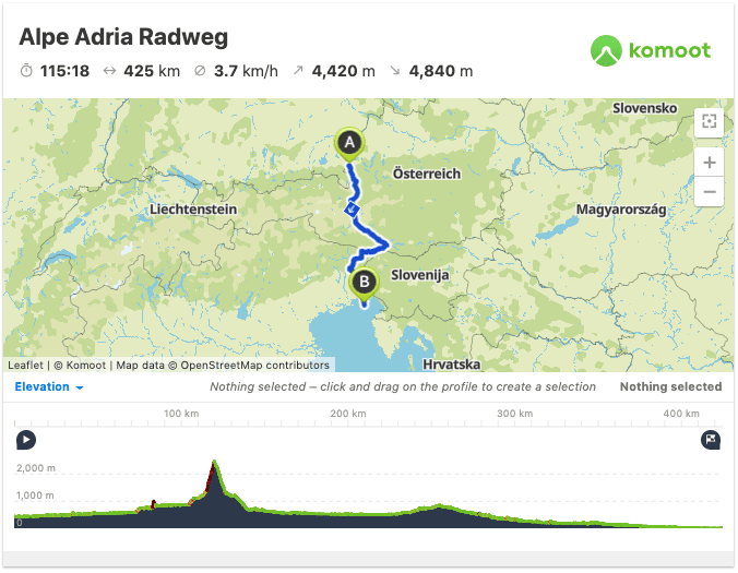
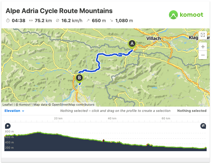
The Alpe Adria Cycle Route is part of the bicycle itinerary leading from Salzburg, Austria, to Grado, in Friuli (Italy). It is a 415km ride, more than 3/4 amidst the spectacular Alpine peaks, a ride that will stun you with its epic landscapes.
Disclosure: Some of our articles contain affiliate links. This comes at no additional cost for you and helps us keep this website up and running. (as Amazon Associates we earn commission from qualifying purchases)
While the Austrian section of the route is very demanding, bringing you up the Little Ankogel at 2,400msl, the Italian part of the bike trail is mostly fairly easy, making up a nice cycling holiday even for families, while expert riders can do it as a day trip.
The ciclovia Alpe Adria (Alpe Adria Radweg) starts from the Austrian border in Coccau Valico, it is 175 kilometers long and will take you from the Carnic to the Giulian Alps to then end up on the Adriatic Seashores. The whole route never leaves the region of Friuli Venezia Giulia.
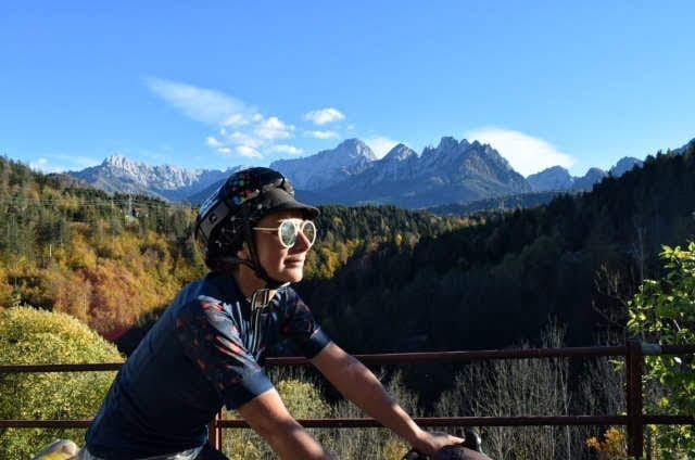
We entered Italy from Austria, coming from Klagenfurt/Villach, and crossing through the Coccau Valico some 12km before Tarvisio (Tarvis). This means we only rode the Italian section of the trail, and that’s what we are going to talk about in this blog article.
Looking for inspiration?
- The magnificent Dunajec River Gorge cycle trail in Poland/Slovakia
- Cycling the Danube from Budapest to Vienna
- A two-week itinerary of Sardinia
- Pineta di Ravenna Cycling Route: from Ravenna to Cervia through the Forest
Alpe Adria Cycle Trail: Description, Map, and GPX track
Coming from Austria, just after the Italian border you’ll have to take a small path on the right that will take you on the Alpe Adria cycle path, it is on the right end of the old border parking lot, easy to miss and not well signposted, so be careful otherwise you will end up on the highway to Tarvisio.
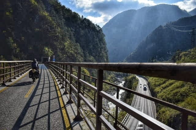
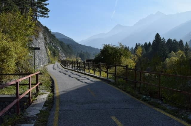
The Alpe Adria cycle path is completely paved and most of the route is dedicated to bicycles only. A few short stretches are interrupted because the works are still in progress. The cycle track is in fact obtained on the old railway line, dating back to the late nineteenth century, that used to connect Vienna to Venice.
There are no exhausting climbs, except for a few hundred meters at a 20% slope found at the beginning of the trail. The elevation profile is quite simple, going from the 620msl where the border stands to the 820msl of Camporosso, 6km after Tarvis, the highest point of the bike path. The average incline of this uphill section is almost not noticeable, at about 2.5/3%.
From Camporosso, the road slowly begins to descend, 60 kilometers of 3% downhill before hitting the Po Valley and becoming flat (and a bit boring). With a profile like this, the Alpe Adria radweg is one of the best routes for beginners to enjoy the Italian Alps on a bike. Entering from the North (Austria) the cycle path will be mostly downhill.
The Alpe Adria in the Julian Alps
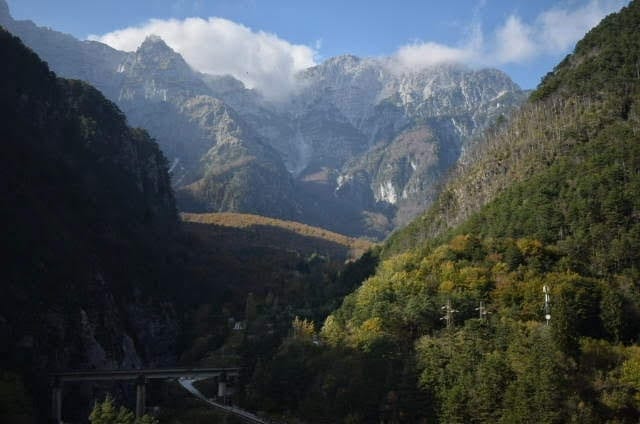
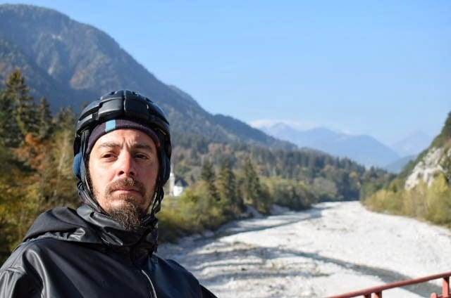
From Tarvis to Gemona, a town hardly hit by the famous Friuli earthquake of 1976, along the path you will always have a magnificent mountain landscape around you, sometimes glimpses of the Fella river, before it flows into the enormous riverbed of the Tagliamento.
The itinerary cuts through the Giulian Alps, the peaks are not too high (an average of 2000msl) but very diverse and certainly scenic. Of course, along the route, you’ll encounter countless trailheads, so planning a day hike here is certainly worth it.
Although the cycle path will always be far enough from the roads, there are several villages along the way, with at least one small grocery store that can prepare a cheap panino. Many restaurants are also available, a good chance to taste Friulian food… remember that restaurants are open only for lunch and dinner in Italy.
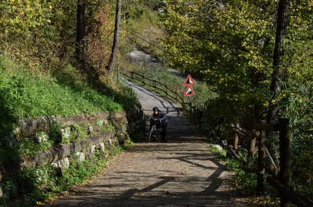
From Tarvisio to Venzone you will have to follow the signs indicating the Alpe Adria cycle path, later referred to as FVG1. After Venzone, the trail is under construction, we rode it in October 2018 so it should probably be completed before summer 2019. Right now the cyclists are forced to get on the state road for a little while, the road is safe enough but of course, it takes away the magic.
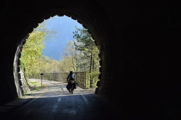
Since the Alpe Adria cycle trail is built up the mountain on an old railway line, there are several tunnels to cross. Those tunnels are, of course, bicycle-only, they are very well-lit and maintained.
Getting out of these tunnels and finding yourself facing a new, gorgeous landscape every time is one of the things we liked the most about the Alpe Adria Trail.
In the map below you can see only the Italian part of the Alpe Adria cycle path
What to see along the Alpe Adria Cycle Route
According to our experience along the Alpe Adria, the part that goes from Tarvisio to Gemona/Tolmezzo is the most scenic. The initial part goes through the Tarvis Forest, famous for the production of resonance wood, obtained from the spruce, and used for the creation of violins and other musical instruments.
Pedaling the Alpe Adria you will always have the high surrounding peaks insight, from the mountains of the Val d’Alba Nature Reserve to Val Resia then descending along the Tagliamento river and the Julian Prealps Natural Park.
Besides what you can admire remaining on the bike path it is also possible to make several detours without getting too far from the trail. Here are some.
Day Trips from the Alpe Adria
- Monte Santo di Lussari, 1790 meters, a peak reachable by cable car from Camporosso or on foot;
- the Orrido Della Slizza, a path along a river with turquoise waters;
- the forest of Tarvis, the largest state-owned forest in Italy, full of hiking trails and where you can also visit the forest museum in Bagni di Lusnizza;
- Church of San Nicolò, famous for the saint’s festival held in December and featuring the Krampus and their parade through the streets of the town;
- Lake of Predil is not very close to the cycle path (it is along the Slovenian border) but a fascinating place worth a detour for a day trip. Located almost 1,000 meters high, near the suggestive abandoned lead and zinc quarries, it is surrounded by the Cinque Punte massif. It’s a 12km uphill ride heading south of Tarvis, you’ll have to backtrack to get back to the Alpe Adria.
How to get to the Alpe Adria trail
In recent years it has become increasingly easy to move on regional trains with bikes in Italy, Tarvis can be reached by train from Venice changing trains in Udine (Udine – Tarvis 1 hour). Remember that bikes are only accepted on regional trains.
If you do not want to limit yourself to the Italian section of the cycle path, you can also reach Salzburg by train from Italy and start pedaling from there.
Renting a bike on the Alpe Adria trail
The Alpe Adria Cycle Trail is so easy that it can be done almost on any bike, even on a single-speed granny. If you don’t have a bike or come from far away and you do not want to transport your bike on planes and trains, you can rent a bike on-site.
Several hotels and campsites near the bike path offer a bike rental service. There are also rental services that are part of the Bikeways European Bike Rental circuit and also offer bike rental and recovery services in case of unexpected events. Many of these centers are open only during the warmest season, from April to October.
Among those, Nassfeld offers a flexible service, while Bandiziol in Camporosso has good bike availability.
Where to sleep along the Alpe Adria cycle path
Wild Camping in Friuli Venezia Giulia
In Italy, the regulations about wild camping have been delegated to the Regions, finding specific information is not easy at all. Often the laws are open to interpretation and it is not clear what are the parameters that distinguish bivouac from camping.
However, it seems that in Friuli Venezia Giulia free camping is not allowed, anyway, with the right precautions a quiet place to sleep can be found without much difficulty, especially if it is not high season.
The Alpe Adria Cycle Path is mostly along forests or rural areas without too many houses in the surroundings. Some usable abandoned buildings can be found along the trail. In general, try not to sleep near the rivers or in plain sight, dismantle the tent at first light, do not light fires, and obviously do not leave a trace of your passage.
If, like us, you follow it during the opening season of the hunting season, pay close attention to where you camp, being woken up in the middle of the night by close shots is not pleasant.
Bike-friendly campsites and hotels along the Alpe Adria cycle path
There are a few equipped campsites along the cycleway, but we could only find three, one in Gemona (9/10€ for bike, tent, and 1 person), and two just next to each other on the shores of the Covazzo Lake in Interneppo (not really along the route).
Several local hotels and BnBs are fishing in the cyclists’ basin by calling themselves “bike-friendly”. Some offer tools for bike repair, rental services, and bike storage.
Have a look at the accommodation options in Tarvisio and around
Hospitality with local people
Another alternative is the use of tools such as Couchsurfing or Warmshowers, you will be hosted by locals and, if you end up being as lucky as us, someone will treat you to a home-made meal based on polenta and frico, which you should definitely try if you go to Friuli Venezia Giulia.
Alternative cycle paths to the Alpe Adria
If you want to explore more this beautiful region, there certainly isn’t a lack of options. Most roads though will feature some epic climbs, so a bit of physical preparation and/or force of will is required.
One of the alternatives, or complementary route, to the Alpe Adria cycle path, is the 3 Nations Tour: 123 km to be covered in 7 daily stages between Carinthia, Slovenia, and Italy which make up the short variant of the Alpe Adria Trail.
Below is the map of the route and the elevation profile.
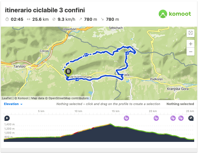
“This loop itinerary leads to the point where the borders of Italy, Austria, and Slovenia meet. Starting from Italy, the cycle path is paved, while over the Slovenian border, where the climb begins, the path is a dirt track in the forest even though with a good and compact surface.
The descent takes place in Italian territory, after a first medium-hard stretch on pebbles it continues on an excellent forest track, before getting back to asphalt.
The ride is doable in both directions but certainly easier counterclockwise (as shown by the GPS track). in the case of a clockwise journey, with an ascent from the Italian side, the track will serve only as a reference, as often there have been cuts through the wood between one switchback and another. ” [from itinerari.mtb-mag.com]
Have you cycled any interesting routes in the area? Let us know in the comments!
Looking for inspiration?
- The magnificent Dunajec River Gorge cycle trail in Poland/Slovakia
- Cycling the Danube from Budapest to Vienna
- A two-week itinerary of Sardinia
- Cycling Poland – GreenVelo and EuroVelo routes (tips and maps)
- Pineta di Ravenna Cycling Route: from Ravenna to Cervia through the Forest