Last Updated on 17 September 2024 by Cycloscope
Everything you need to know about the longest suspension bridge in the world, the Charles Kuonen Suspension Bridge in Switzerland. When to go, hiking distance…
The longest suspension bridge in the world, the Charles Kuonen Suspension Bridge in Switzerland was opened back in July of 2017. At the time I remember it was widely reported in the media, and even my Dad was asking me if I had been yet.
Disclosure: Some of our articles contain affiliate links. This comes at no additional cost for you and helps us keep this website up and running. (as Amazon Associates we earn commission from qualifying purchases)

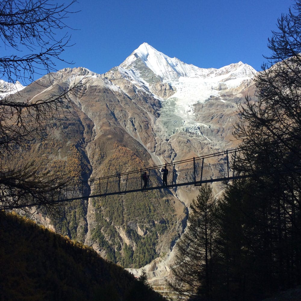
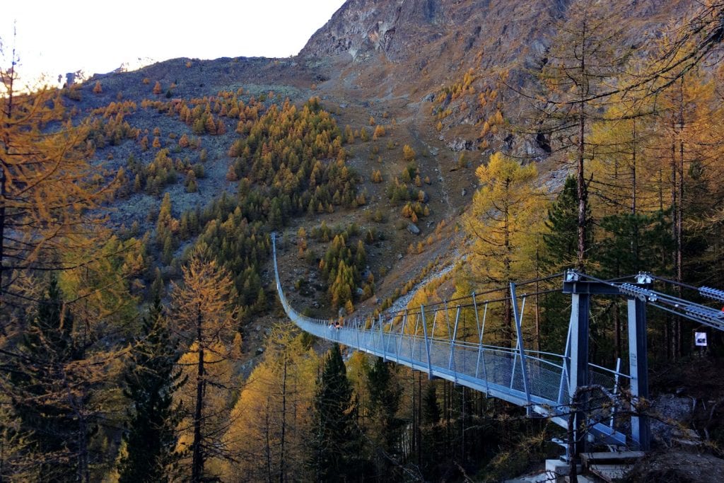
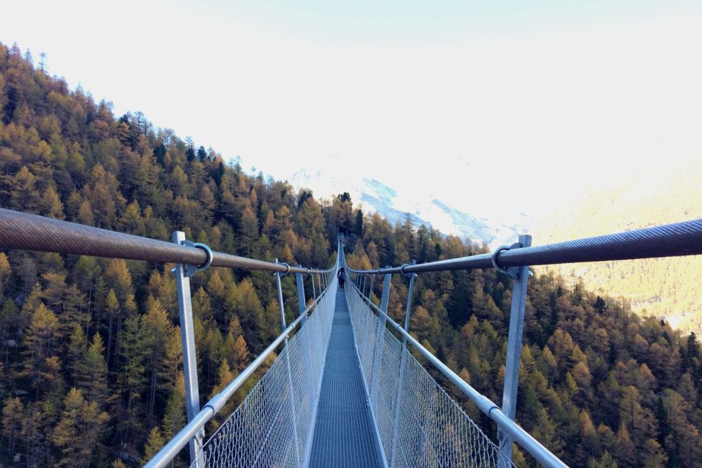
It is an impressive 494 meters (1621 feet) long and quite a sight to behold from a distance. The construction is made of extremely thick metal cables and metal plates, so it’s very very safe. The walkway itself is very stable and easy to cross.
However, because it is so high above the Mattertal Valley, getting up to the Charles Kuonen Suspension Bridge can be quite an effort. Especially if you are not fit.
So, let’s dive into this first-hand guide about hiking the Charles Kuonen Suspension Bridge, one of the most unique places to visit in Switzerland.
This blog post is contributed by local expert Roger Timbrook
Roger is a mad traveler and lover of the outdoors. Originally from Australia, he is now living in Switzerland where he spends most of his time traveling, blogging, hiking, or mountain-biking. You can find him online blogging about Switzerland or on X.
The Hike to the Charles Kuonen Suspension Bridge
Track Link: https://www.wikiloc.com/hiking-trails/randa-pont-suspendu-charles-kuonen-randa-20152661
Distance: 7.25km or 4.5 miles
Elevation Change: 2100ft or 650m (up and down)
Overall hiking time: 2hrs up 1.5hrs down (varies depending on fitness)
The hike itself is a circular loop from the town of Randa, which is just down the valley from its famous cousin – Zermatt. Home to the even more famous Matterhorn mountain. As such, you can do the hike in either direction. However, the right-hand side is a little more gradual and therefore recommended. Just keep in mind that that also means your descent will be steeper.
The path winds its way slowly but steeply through the forest on both sides and is rarely supplemented with any handholds or rails that I can recall. As such, be aware this is a wild hiking path. And for most of the hike, you won’t see a lot, until you reach the bridge. So, it’s a surprise of sorts, both seeing the bridge and suddenly seeing the stunning mountains around you.
The Charles Kuonen Suspension Bridge itself was actually constructed to replace an older one that is part of a longer walk along the Mattertal called the Europaweg. So, you can do a longer walk if you wish. However, the bridge itself is definitely a goal worth reaching. The views are stunning, and the experience of standing in the middle of it is second to none.
The complete hike is around 7.25km or 4.5 miles from the town center and back. In terms of elevation, the bridge is around 2100ft or 650m above the town. This is where fitness comes in. Ascending anything over a few hundred meters is doable, but if you are very unfit, I would not recommend it.
Being Prepared For The Hike
This hike is no “walk in the park”. Even if it appears like it is on paper. Also be aware that if you ask a local about it, they will think it is quite easy. Be aware: the Swiss are often super fit, born in the mountains, and hike like mountain goats into the 80s.
My advice: come prepared with appropriate shoes (with decent grip, like hiking boots out or similar), a few layers of clothing (t-shirt, sweater, and a rain jacket), enough water (at least half a liter – 17oz), and maybe even a snack. Of course, if it’s sunny, bring sunscreen, sunglasses and a hat too. The sun is even stronger at altitude, so you can burn very easily. Oh, and you should have a decent daypack to carry all this in too, because you will be on the trail for 4-5 hours in total.
Sure, you can get lucky and have completely sunny weather, make it up in flip flops, and not take any water. However, dozens of people are injured or stranded in sudden storms each year in the Alps, and you should avoid being one of them. The conditions in the mountains can change very quickly, even if it is sunny when you start.
Getting There
We stayed overnight in Randa specifically to do this hike, however, it can be easily reached by train from Zermatt. Trains generally go twice an hour and take 17 minutes. Yes, they are Swiss trains, so they will be on time and the trip will likely take exactly 17 mins.
If you are coming specifically here, you have to take the train to Zermatt from Visp in the South of Switzerland. There are major connections here from all over the country. Just check the Swiss Railways website for the specifics.
If you are driving, just be aware that there is limited parking because this is quite a small town. So, I recommend arriving early. A few parking spots I am aware of include:
- Next to the train station
- Next to the church
- And it seems there is now a specific one because this hike is so popular
Once you arrive in town look for the yellow hiking signs to lead the way. I believe the locals have also added specific, extra “hanging bridge” signs now too. If you arrive at the train station there will be yellow hiking signs leading the way there. If you don’t see them at first, just wander around the area outside the train station until you see them.
Best Time To Do The Hike to Charles Kuonen Suspension Bridge
Although this hike is not very high, at least in terms of Swiss hikes, it is best to do it as late as possible in summer. That means aiming for June/July at the earliest to ensure there is no snow. At the time of writing, there has not been a huge amount of snow, however this varies wildly from year to year.
Officially the Charles Kuonen Suspension Bridge is open from May until October, so you can attempt the hike at any time in this window. However, if you are coming in either of those months (May & October) consult the local tourist offices before heading out to make sure it is safe and snow-free.
Zermatt
If you are in the area, it is definitely worth exploring Zermatt and the mountains above a little further. This is one of the most stunning areas in Switzerland and you could easily spend a few days to a week here.
In terms of hikes, the most popular and stunning ones include
- The five lakes hike, high above the town passing from lake to lake
- The easiest, Gornergrat 360-degree loop, worth doing when you head up there.
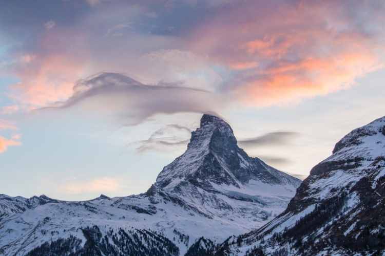
- For the more adventurous – hike to the Hornlihütte, where the mountaineers start their descent of the Matterhorn from
And if you want that iconic shot reflection of the Matterhorn in a lake while you are here, head to the Riffelsee early in the morning or late in the evening when the wind is still. This can be reached from the top of the Gornergrat, so you can combine a visit to both.
Other Hikes In The Region
Switzerland is overflowing with hikes so you are spoiled for choice when you are here. And the southern part of Switzerland, around Zermatt has some of the best I have done. Some worthwhile hikes include:
- Any part of the Haute Route from Chamonix to Zermatt
- Hike to the Cabane du Moiry for a stunning glacier view
- Head to the neighboring valley of Saas Fee which is a little less popular, but no less stunning
- Visit the longest glacier in Europe – the Aletsch and do the Aletsch Glacier Trail from Riederalp
Read Also