Last Updated on 26 November 2025 by Cycloscope
Cycling across Nepal from west to Pokhara: quiet roads, friendly locals, affordable guesthouses, and great weather in late winter and early spring.
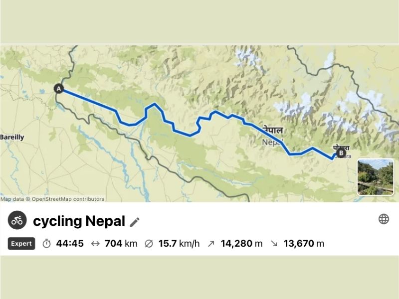
Our day-by-day itinerary, road conditions, accommodations, costs, and the GPX track of our route.
We spent about two months in Nepal, from mid-February to mid-April. The season is excellent for cycling, as it’s not too hot in the lowlands and not too cold in the mountains.
Disclosure: Some of our articles contain affiliate links. This comes at no additional cost for you and helps us keep this website up and running. (as Amazon Associates we earn commission from qualifying purchases)
However, the views, especially in the more touristy areas, are not the best if the day is too polluted.
Pokhara and Kathmandu are among the most polluted cities in the world, and we had to give up on some hikes in the surroundings due to the lack of visibility. October and November, after the rains, are supposed to be better periods.
We entered Nepal from the west, after cycling through Uttarakhand (India), and enjoyed every single day. In the western part of the country, traffic is almost non-existent, and so is tourism. Up until Pokhara, we didn’t meet any tourists, apart from a few lone cyclists.
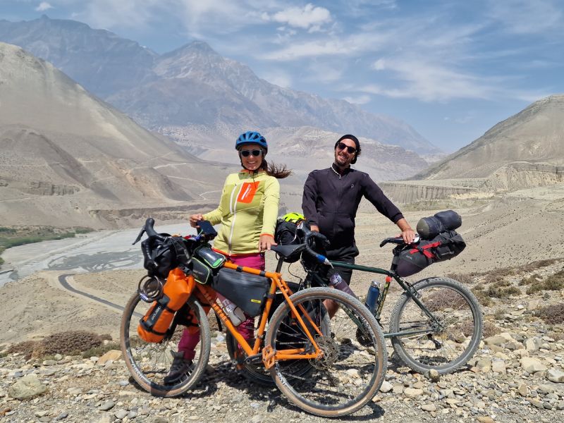
We traveled bikepacking without a tent and had no problems, as guesthouses are easy to find, very affordable, and the temperature drops quite a bit in the evenings during this season. However, if you want to ride mountain routes in less frequented areas (especially at high altitude), it’s always recommended to carry a tent and a sleeping bag with you.
Finding water and food is not a problem, at least along the route we took. Nepalese people are very welcoming, and you can always ask them if you need anything—they will be happy to help.
Info about Nepal
- Currency: Nepal uses the Nepalese Rupee (NPR, Rs). Cash is the most common form of payment outside big cities. ATMs are widely available in Kathmandu and Pokhara, but less so in rural areas.
- Meal: The staple is dal bhat (lentil soup with rice, vegetables, pickles, and sometimes meat). A basic local meal costs around Rs 200–400 ($1.50–3), while a restaurant meal for tourists ranges from Rs 500–1,000 ($4–8). Western food is common in Kathmandu, Pokhara, and trekking hubs.
- Hotel: Accommodation ranges from simple guesthouses at Rs 800–1,500 ($6–12) per night to mid-range hotels at Rs 2,000–5,000 ($15–40), and luxury resorts above Rs 10,000 ($75+). On trekking routes, teahouses are available almost everywhere, usually charging modest rates with meals included.
- Road Conditions: Main highways connecting Kathmandu to Pokhara, Chitwan, and border towns are paved but often crowded, with frequent landslides and roadworks during the monsoon. Secondary and rural roads can be rough, dusty, or muddy depending on the season. Traffic in cities is hectic.
- Best Season to Cycle in Nepal: The ideal seasons are autumn (October–November) and spring (March–April) when the skies are clear, temperatures are pleasant, and roads are drier. The monsoon (June–September) brings heavy rain, landslides, and slippery tracks, while winter (December–February) can be cold in the mountains but still good in the lowlands.
- Visa: Tourist visas are available on arrival at Kathmandu airport and major land borders. Options are 15 days ($30), 30 days ($50), or 90 days ($125), with extensions possible up to 150 days per year. You can also apply online in advance via the Department of Immigration’s portal.
2. ACAP Permit (Annapurna Conservation Area Permit)
- Cost:
- NPR 3,000 (about USD 23) for foreigners
- NPR 100 for SAARC nationals
- Where to get it:
- Nepal Tourism Board in Kathmandu or Pokhara
- Entry checkpoints in the Annapurna region
Documents you’ll need
- Valid passport
- Two passport-size photos
- Payment in Nepali rupees (cash)
Validity
- Both permits are valid for the entire Annapurna region and last for the duration of your trek. There’s no daily limit, but you must carry them with you since there are several checkpoints along the way.
Day 1 – Banbasa Border Crossing
Coming from Uttarakhand, we cross the land border to enter Nepal in Banbasa, which is one of the most beautiful crossings we’ve ever had. Few people, a lovely road through the forest, then across the river, and many monkeys stealing our precious dried fruit. The immigration officers will give you a stick to defend your food, but it was too late for us…
We have to remove our bags one by one for baggage inspection, but other than that, everything goes smoothly and peacefully. And once again, I can confirm that classic panniers are 100 times better than a bikepacking setup—disassembling and reassembling everything took forever.
After the inspection, you have to keep cycling for a while before you encounter the small immigration office. We asked many times for directions because it felt like we were basically cycling in the village without a Visa. At the immigration post, they have a wifi connection, you have to fill out the application form online, and you can pay cash. We got a 3-month visa to be safe, and off we go!
Nepal Visa Options
- 15 days – $30
- 30 days – $50
- 90 days – $125
Extensions: You can extend up to 150 days total per calendar year at the Department of Immigration in Kathmandu or Pokhara. The minimum fee for up to 15 days of extension is USD 45
E-Visa: Nepal offers an online pre-application system where you fill in details and submit your photo, then pay at the airport or land entry point.
Passport Validity: Must be valid for at least 6 months.
Day 2 – Day Off in Mahendranagar
We bought two SIM cards and exchanged our Indian rupees—zero commission—at a pharmacy recommended by our friend Yassine (you can find the spot on iOverlander). Yassine is one of those people we keep bumping into by pure chance over the years: first in Zambia, then in Malawi, later in Tanzania, and now again in India and Nepal.
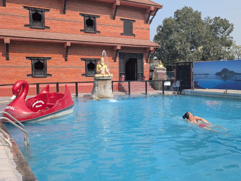
As usual, when entering a new country, we took a day to slow down. A bit of laundry, some rest, and, most importantly, a visit to the Mahendranagar Museum. Entry was just 100 rupees (about 70 cents) for both sections of the museum, plus another 100 rupees for swimming.
Yes, the museum really does have a swimming pool—with pedal boats! After a dip and a plate of momos, we headed inside. But the museum wasn’t at all what we expected. No ancient artifacts, no Nepalese history, no prehistoric relics.
Instead, the first two floors were dedicated entirely to illusions. A friendly guide followed us around with great enthusiasm, showing us the best spots and angles for fun photos. The results were hilarious.
The second section turned out to be the aviation museum, complete with a real airplane converted into a gallery. Inside, we found a photo exhibition of Nepal and other destinations visited by the museum’s founder, along with a video presentation in which he explained his vision: to inspire young Nepalese to develop a passion for aviation. The area also included a mini zip line, a helicopter, and a collection of model airplanes.
Only later did we learn more about the story behind it. The Mahendranagar Museum was founded by Captain Bed Upreti, a former Nepali pilot, through the Captain Bed Upreti Trust. It opened to the public on 13 November 2020 in Bhimdatta (Mahendranagar), Kanchanpur.
At its inauguration, a statue of Captain Upreti’s mother, Saraswati, was unveiled to honor her support and the land donation that made the project possible. The museum is part of Upreti’s larger effort to create aviation-themed cultural spaces in Nepal, following his earlier projects in Dhangadhi and Kathmandu.
Day 3 – from Mahendranagar to Chaumala

Crossing a border always invites comparison with the country left behind. In Nepal, the differences reveal themselves immediately. To our great relief, drivers don’t honk their horns nonstop as they do in India—and yet, somehow, traffic still flows and everyone survives.
The roadsides are noticeably cleaner, though admittedly that’s not a high bar. We see more bicycles on the road and, to our surprise, many young women riding scooters and bikes—something we could count on one hand during our time in Uttarakhand. In the first city we enter, we even spot bike lanes, though they’re mostly filled with parked scooters. That, amusingly, feels a bit like Italy.
The warmth of the people is familiar. Like in India, we are greeted constantly, but the smiles here feel softer, gentler, more distinctly Asian. English is widely spoken—even in small towns—while in India, we often struggled outside the big cities.
The food hasn’t changed much: paneer, chicken, dal, momos, mutton, and river fish make up the menus. The first sixty kilometers of flat road slip by easily, with light traffic and a peaceful backdrop of farmland, water buffalo, and forest.
Day 4 – Chamaula to Chisapani
The second day of cycling in Nepal is similar to the first—countryside scenery and forests with a few larger villages here and there. Today is a holiday, so there are far fewer cars and trucks on the road. All morning, we mostly encounter bicycles and motorbikes.
Today marks Rastriya Prajatantra Diwas, Democracy Day. It commemorates the end of the Rana regime in 1951 and the beginning of democracy in Nepal. The movement led to King Tribhuvan’s return to the throne under a more open system. The monarchy was later abolished entirely in 2008.
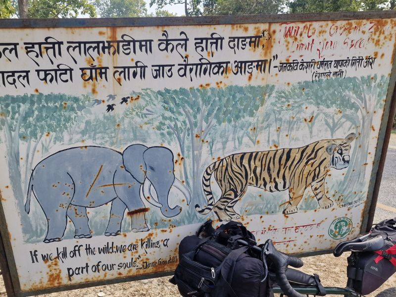
Around 3:30 PM, we arrive in Chisapani, a village famous for its long suspension bridge over the Karnali River, one of the longest in Nepal. The bridge is a vital connection for locals and offers beautiful views of Bardia National Park.
However, we won’t continue toward the park, where cycling is not possible for about 20 km after the bridge due to tigers. Nepal has done a great job tripling its tiger population, but coexistence with humans remains a challenge. If you want to proceed, the rangers will find you a lift to the other side of the prohibited area.
Instead, we’ll take a dirt/sandy road from Chisapani to Baddichaur, where we’ll reconnect with the asphalt. We’ll see tomorrow what to do—heavy rain is expected, and sand + water is never a good combination.
In the meantime, we enjoy a cold beer with river fish curry and fried paneer before heading to bed in our clean little room at Look Hotel and Lodge, which we got for €7—since we picked the one with a river view. Rooms with no view is €4.80. Hot water, WiFi, and air conditioning for when it gets warm are included!
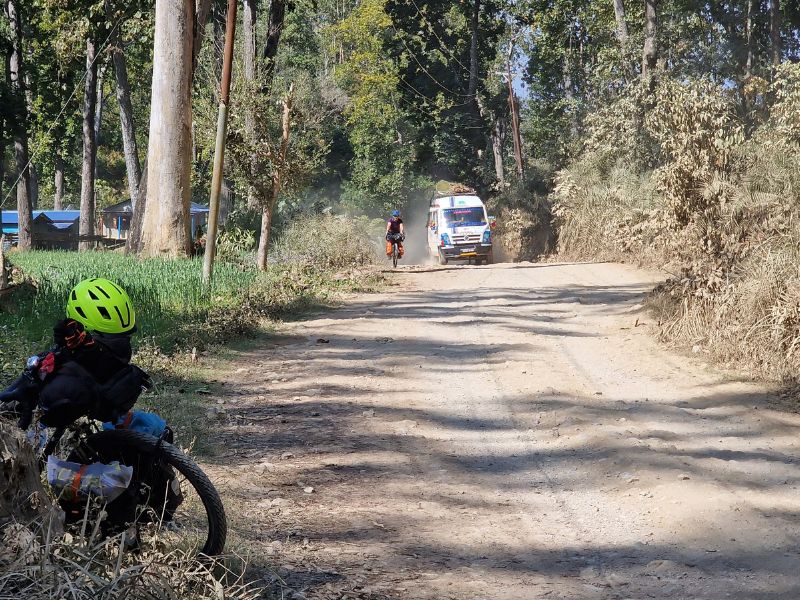
Day 4 – from Chisapani to Babiyachaur
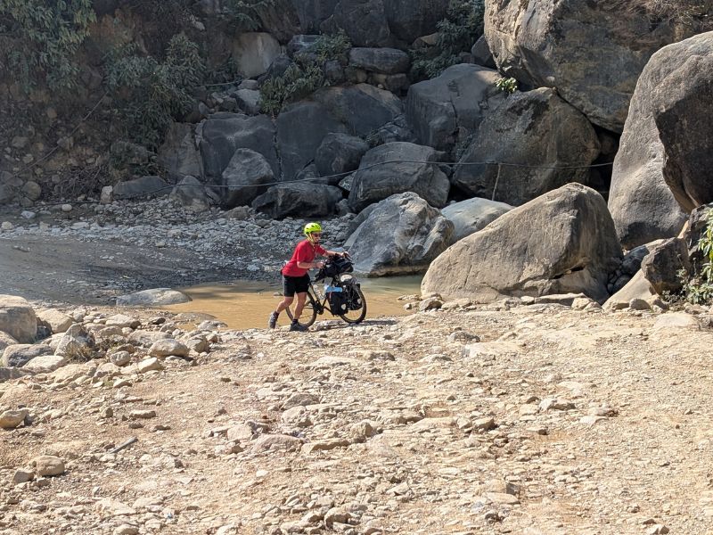
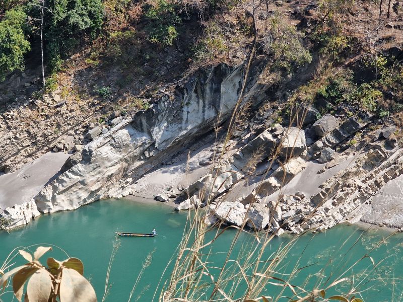
We leave Chisapani, following the Karnali River north. The road quickly turns into a dirt track, and by “dirt,” I don’t mean the smooth gravel roads of the European countryside. I mean a stretch of rocks and sand that I can’t even imagine during the rainy season.
We knew this—other cyclists had warned us—but they often forget to mention the most important thing: yes, the road is terrible, but the landscape is stunning.
The turquoise, calm river, a few fishing boats rowing, the cliffs in various shapes, and the lush forest.
After 11 kilometers, we pass through the beautiful village of MP Bazar, Kuine. Cultivated fields, two-story mud houses—it feels like riding through a fairy tale.
We keep following the river, passing through villages, fields, forests, and some annoying kids.
Another bridge, and the road somehow gets even worse. More pushing, both uphill and downhill.
Then we bump into a Hotel out of nowhere, with a giant swimming pool, Wi Fi (which is everywhere on this road), and AC for 10 euros.
Unfortunately, the pool will be open in two months because, despite the 31°C temperature, it’s still considered winter.
Day 5 – from Babiyachaur to Baddichaur
There are still about 20 kilometers to go before reaching asphalt, and we had hoped the road conditions would improve as we approached the main road. Unfortunately, this wasn’t the case. The track became even more challenging than the previous day, with steep, sandy climbs that forced us to push our bikes for stretches at a time.
Traffic along this section is minimal—just the occasional minibus or truck—but when they pass, they raise thick clouds of dust that make progress less pleasant. The scenery remains attractive, though not quite as dramatic as the previous 30 kilometers, which makes the ride feel more tiring.
We finally reached asphalt in Baddichaur around 2 PM and found a simple guesthouse for about €5. Facilities were basic: a cold shower (welcome in the 30°C February heat) and a bed of wooden planks with a thin, very firm mattress. After years of traveling in Asia, we’ve grown accustomed to these conditions, though it sometimes means waking up with numb arms or hips.
Dinner was a highlight: a generous Veg Thakali Khana, Nepal’s version of the Indian thali, complete with rice, lentils, vegetables, and pickles.
The plan for tomorrow is to continue on the fast asphalt road towards Birendranagar, the capital of the Karnali region. With a population of around 150,000, it promises more comfort—and maybe even cheesecake for a snack.
Day 6 – from Baddichaur to Birendranagar
Despite being back on asphalt, the traffic is almost nonexistent. It seems that not many people own cars around here, or perhaps everyone relies on public transport or motorbikes.
There are a couple of climbs to Birendranagar, totaling about 800 meters, just like almost every other day. The road winds mostly through the forest, providing much-needed shade for most of the way.
After a night on a wooden bed, today we treat ourselves to a comfortable room and a slice of cake at a nearby bakery.
Birendranagar, the capital of Karnali Province in western Nepal, is named after King Birendra, who was assassinated in the Narayanhiti Royal Palace massacre. Crown Prince Dipendra carried out the attack, killing ten family members before taking his own life.
A popular legend in Nepal says the Shah monarchy was destined to last ten generations before coming to an end. Coincidentally, King Gyanendra, the last ruling monarch, was the tenth in direct succession from Prithvi Narayan Shah. His reign ended in 2008 when Nepal abolished the monarchy and became a republic.
Back to present-day realities, pollution remains a big issue here. Although they call it “fog,” the Indian border is close, and there are no mountains to block the haze. We also noticed garbage dumps where trash is simply set on fire—something that certainly doesn’t help.
Day 7 – from Birendranagar to Devashtal

From Birendranagar, we start with a long descent to Chhincu, where the road becomes seriously rough.
From the 50th kilometer and for the next 20 kilometers, the landscape turns truly enchanting. The clouds bring the perfect temperature to enjoy it. Even today, with ups and downs, the total ascent is 900 meters. More or less, it will be like this every day until Pokhara.
We’re staying in Devashtal, in a €7 hotel—one of those where you can charge an electric car or the many electric minivans. We have a delicious Thakali Khana, a hot tea, and we’re ready for bed.
Day 8 – from Devashtal to Chaurjahari

After a delicious omelet + roti + veggies, we’re back on the road toward Chaurjahari, today’s destination.
As usual, about 900 meters of elevation gain, only to end up at the same altitude again.
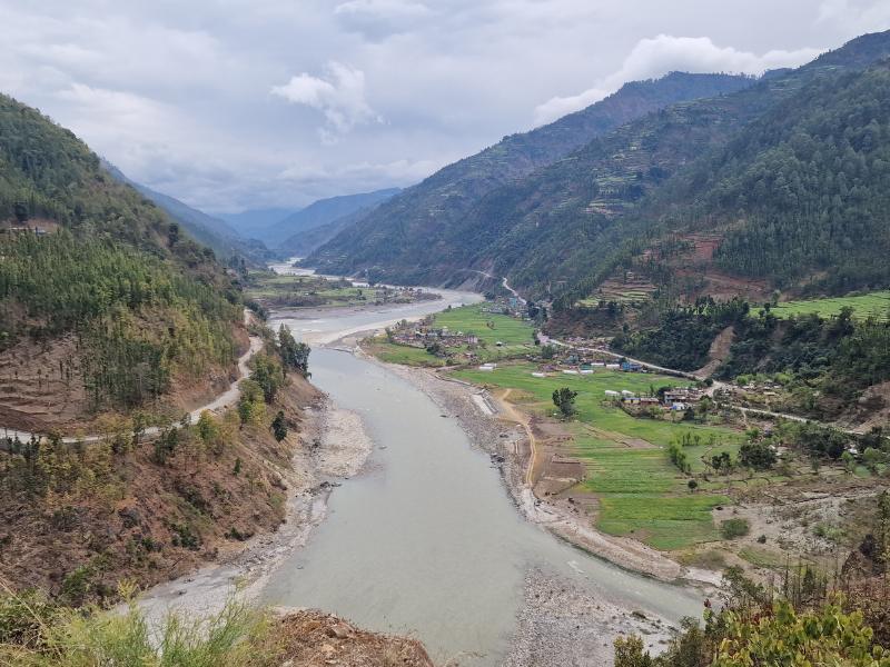
We take the F047 along the Bheri River, a beautifully paved road with zero traffic. This road leads to Jajarkot, but we will take the pedestrian bridge at Kudu to proceed on the Pushpalal Road.
Pedestrian bridges are numerous, some very long and narrow. I’m not in a rush to cross them with my bike, but the alternative is pushing the bike up the climb to Jajarkot—so I’ll take the scary bridge.
The sky remains cloudy all morning, with occasional raindrops.
The overnight rain has made the landscape much crisper and cleared away pollution.
We pass through beautiful villages with small and large houses made of mud and stone—some vibrantly colored, others natural, with carved wooden doors and windows.
Many water buffalo and countless sheep take shelter under roofs, avoiding the looming rain.
And then the real rain comes. It seemed like a passing shower, but it stayed with us for the next four hours, pouring nonstop.
The road remains beautiful even in the rain, but if a pickup passed by, we would gladly ask for a ride. We’re soaked. We are left with no choice but to keep pedaling.
Finally, we reach Kudu, already dreaming of a hot shower—just need to cross the bridge.
But first, a one-kilometer descent down an impossibly rocky path (about 100 meters of elevation loss). By the time I reach the bridge, I’m so exhausted and drenched that I barely fear the crossing anymore.
This bridge is shorter than the others. I need to sing There Was a Crocodile seven times, and I’ll be on the other side.
Then, a final climb—100 meters up in 800 meters, this time on asphalt.
We arrive at an unexpectedly clean hotel.
Unfortunately, the power is out, but a kind young man brings us a bucket of hot water for washing, along with dinner and tea in our room.
Day 9 – from Chaurjahari to Sanibheri
We wake up at 7, and it’s still raining, so we take it easy.
We have breakfast, give the bikes a quick rinse, and discover that the hotel owner also sells powdered caterpillar fungus supplements.
Caterpillar fungus is a rare and highly prized medicinal mushroom, known for their supposed energy-boosting and healing properties. They are a rare parasitic fungus that grows on the larvae of ghost moths in the high-altitude regions of the Himalayas and the Tibetan Plateau.
We set off around 11, and the rain has stopped—in fact, the sun is peeking through.
The road gets even more beautiful, and traffic is nearly nonexistent—just a few buses, taxis, and scooters. It feels like no one owns a car here, which makes sense since most roads would require a 4×4.
Today, we stop early, around 2:30 PM, in the village of Sanibheri after 28 km and 650 m of elevation gain.
Tomorrow will be a tougher day.
Day 10 – from Sanibheri to Rukumkot
The unexpected dirt road.
After about ten pleasant kilometers along the river, we reach a junction. To the right is the road to Musikot, and to the left, the one to Rukumkot (the famous Pushpal Highway).
Both seem paved, and by mistake—but also luckily—we don’t check the satellite map to confirm if the asphalt continues.
A couple of kilometers later, the road turns into a small rocky dirt track passing through a charming little village. Daniele is ahead, and I stop several times to check the map, convinced we’ve taken the wrong road.
But no, this is the right one. Luckily, after a few kilometers, it improves, but it remains unpaved. We only encounter one car, which gets stuck in the mud right in front of us.
A few hours later, they passed us—they took a while to get free. We see them three more times throughout the day, seemingly going back and forth transporting supplies for the locals.
This area isn’t far from the paved road, yet it feels truly remote. Most houses are on the other side of the river, near the water. On this side, only a few people live, with just a couple of small villages.
The view from here is breathtaking—we’re glad we took the wrong road. The finale, though, is brutal: almost 500 meters of ascent over about 4 kilometers, forcing us to push our bikes up to Rukumkot, where the road to the highest pass of this route begins—at 3,200 meters.
Day 11 – from Rukumkot to Burtibang
From Rukumkot, there is a brutal 27 km dirt-road climb ahead, and we just heard that two days ago, half a meter of snow covered the pass, trapping several cars.
Since we believe suffering too much for no reason is pointless, we take a bus to Patohalne, the top of the pass. We leave at 10 AM and arrive at 2 PM, including a well-deserved lunch break.
My step-counting app congratulates me for reaching my daily goal, but I haven’t walked at all! The bus moves so slowly, stopping constantly to load sacks and passengers, that the app thinks I’m walking.
The climb was truly brutal—I’m sure I would have been pushing my bike the whole way. The people living on this side of the pass have quite poor houses. They make wool, and we see several women weaving.
At the top, the snow is still there, but the road is clear, and the sun is shining. We take our bikes down from the roof of the bus (all buses have roof racks), and while the ticket collector and a few passengers have fun trying to ride my bike, we bundle up with jackets and gloves, ready for the descent.
From here on, like magic, the road is paved, and naturally, the houses look nicer, and the people seem much wealthier than those on the other side of the mountain.
The descent is long and very enjoyable, with spectacular scenery as always. We reach Burtibang, the gateway to Dorpathan Park. Unfortunately, we won’t visit it because Dani can ride but not walk.
The town is very welcoming—and not just because I find pizza and cappuccino! In the evening, kids play in the streets, adults chat and stroll around, and the lack of traffic makes everything feel peaceful.
Day 12 – from Burtibang to Hatiya
Up and down, countless terraced fields along the river. After the usual 900 meters of ascent, we reach Hatiya.
Hatiya means “marketplace”—historically a trade hub where locals gathered for commerce.
For some reason, there are many Tandoori restaurants here, and we couldn’t be happier! Naan, paneer kadai, dal makhani, chicken tandoori—a feast! All for just €7, drinks included.
Hopefully, this fuels us for tomorrow’s 1,200-meter climb to 2,200m, before descending to Baglung.
Day 13 – from Hatiya to Baglung

The climb starts right after Hatiya. It’s not as terrible as we were told, but it’s no walk in the park either.
The sky is covered in “fog,” and after four hours of climbing, there’s no view of the high mountains waiting for us. The terraces are pretty epic tho.
The joy of starting the descent lasts only a couple of kilometers before the road suddenly turns into dirt. In Nepal, a dirt road is never just a simple dirt road—it looks like it’s been bombed.
We were told that only 4 or 5 km would be rough, but as usual, drivers have no sense of distance. The entire descent is unpaved, shifting from rocky terrain to sand and dust.
Though not too busy, we encounter more Mahindra vehicles and minibuses than usual—enough to cover us in dust with every passing one.
We reach Baglung, a much larger town than we expected. It seems like a nice place. It’s famous for Nepal’s longest Tibetan bridge, the Golden Bridge, standing 122 meters high and 567 meters long.
Day 14 – from Baglung to Pokhara

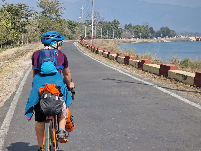
We arrive in Pokhara and find a room for €10 per night in a hotel recommended by an Italian girl we met in Birendranagar, who is starting a school in the mountains (with Pradiya Foundation)
The hotel is by the lake (the tourist area of Pokhara stretches about 3 km along the lakeshore) but on a quiet street, right in front of the entrance to Komagane Park.
Hinduism is not widely practiced here, or at least not visibly. They hold an Aarti for tourists and have even built a massive Shiva statue in the mountains—again, mainly for tourists (especially Indian ones). Across from our hotel, in the park, we hear that a real Aarti is held every Monday for locals. Since it happens only once a week, we decided to check it out.
The difference from an Aarti in India is striking. For one, the crowd is much smaller and mostly elderly. The music comes from speakers instead of being played live, and there’s never that moment of surrender where people start dancing. Overall, it feels quite dull—almost like a church service.
But then, out of nowhere, a man dressed as Nataraja appears, complete with a wig, trident, and leopard-print outfit, and starts dancing. It’s pretty cringe, but at least it wakes us up for a few minutes. The temple itself is lovely, and we’re hoping for some rain to clear out the pollution so we can finally see the mountains around the lake.
Apparently, we should be able to see Fish Tail from our room, but right now, we can’t even make out the nearby hill…
So, we’ll focus on the most important activity in Pokhara—trying all the restaurants (no more thali for a while).
In a few days, Holi (the festival of colors) will take place. I missed the Indian one by just a couple of days 2 years ago, so I’m especially excited to experience this one!
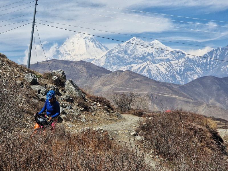
Day 15 – A bit of the Annapurna Circuit – Jomson

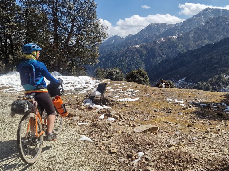
After a few days of rest in Pokhara—also waiting for the rain to clear away some of the pollution—we take a bus to Jomsom. To complete the full Annapurna Circuit, you have to start from the other side, since from the Jomsom side, the 5,400-meter pass isn’t doable with bikes on your shoulders. Our plan, instead, is to take the bus to Jomsom, cycle up to Muktinath at an easy pace, covering just a few kilometers a day, and take long hikes in the surrounding area.
We buy our tickets, and at 6:30 in the morning, the bus sets off. The road, especially at the beginning, is in terrible shape, with heavy traffic—I definitely wouldn’t have wanted to ride it uphill on a bike. The bus jolts and rattles constantly, and we can only hope our bikes strapped to the roof are holding up.
The Annapurna Circuit must have been truly spectacular a few years ago, but now almost the entire route is accessible by vehicle (except for the pass). Hotels line the way, and prices are high compared to the rest of Nepal.
Honestly, we miss the peace and authenticity of West Nepal. Of course, there are still plenty of lesser-known trails here, but to explore them, you’ll need to be equipped with a tent, a sleeping bag, and food.
Eventually, we arrive in Jomsom, where, to our surprise, we struggle to find a place to stay—everything is full. Apparently, there’s a Hindu festival taking place, and crowds of people are making their way to the temple of Muktinath.
We take a day off to get used to the altitude and to do some hiking. We cross a Tibetan bridge, leaving behind the dusty road of Jomsom, and climb up to the Kutsab Terenga Gumba. A man who was dozing on a bench, probably the keeper, opens the door for us and shows us the 15th-century paintings, which are truly beautiful.
Unfortunately, the language barrier prevents us from learning much more about this place.
We descend towards the “Dhumba” lake, pay an entrance fee, but the lake turns out to be a tiny puddle of water, probably created for tourists. Moreover, it is right along the road, clearly visible without the need to pay.
We continue towards the village of Thinigaun, which is completely different from nearby Jomsom. It is a traditional village with several homestays and many yaks, which in this area are very small.
The houses have the typical inner courtyard and firewood stacked on the flat roof.
We walk through the narrow alleys, then through the fields, mostly apples, which are very famous in this area, and reach another Tibetan bridge that brings us back to Jomsom.
Jomson to Kagbeni

An idyllic road takes us from Jomsom to Kagbeni, about ten kilometers further on, with the road almost flat and the wind in our favor.
Kagbeni is a small village we didn’t expect. Although it’s on the Annapurna circuit, there aren’t many tourists, and especially, no caravans of local pilgrims. It seems they go from Jomsom to Mukhtinath and back.
Kagbeni is, of course, full of hotels and guesthouses, mostly in traditional style but with rather adventurous menus, and prices five times higher than those in the rest of Nepal we’ve seen.
From Mexican burritos to pizza to tuna macaroni, there’s nothing missing along this “trek,” which, aside from the pass, is a road that can be traversed by motorcycle and jeep. Of course, one can stay off to the side of the road on the path, but it’s still right next to the road.
There are definitely more interesting treks in Nepal, but to us, cycling through western Nepal has felt much more like “trekking” and definitely more remote than the Annapurna circuit.
So we’re happy to stroll through the streets of Kagbeni, and tomorrow we’ll stay here to explore some nearby paths toward Sangda, a truly remote village where I’m sure you won’t find pizza or tuna.
The local name of Kagbeni is “ghaak” which means narrow junction, because this is the place where four routes meet, and from here the king used to control and tax all the salt trade traffic from Dolpa, Tibet, Manang, and India.
The 108-room Kag Khar dynasty palace is now in ruins.
In Nepali, the word Kagbeni is derived from the words ‘Kag’ and ‘Beni’, in which ‘Ka’ means Kali, ‘Ga’ means Gandaki, and ‘Beni’ means the confluence of the two rivers Kali and Gandaki.
Kali River comes from Damodar Kund, and Gandaki River comes from Muktinath, and Kagbeni is the place where these two rivers mix.
According to Puranas, Kagbeni is also known as Yakshya-Tirtha, because Nalakuyvera and Manigriva, the sons of the demigod Kuvera (Yakshya) passed through Kagbeni on their pilgrimage to Muktinath.
According to Ramayan, Kagbhusundi meditated here on the suggestion of Saptarishis, after which it’s named Kagbeni.
Also, Guru Rimpoche was staying in this area to protect the place from the demon.
Originally, Kagbeni was surrounded by a strong defensive wall, and there were only two entry-exit gates on the Northern and Southern sides guarded by human guards.
A century ago, two Khenis (ghost eaters) representing a man and a woman replaced the human guards at either entry-exit gate of Kagbeni.
Above Kagbeni lies a series of cave ruins that date back to prehistoric times. There are more than 10,000 abandoned cave settlements throughout Mustang, dug into the sides of cliffs.
Nearly all evidence about their history has been erased with time. It is believed that some of these caves were used by Buddhist scholars to meditate to become monks or fulfill their meditation.
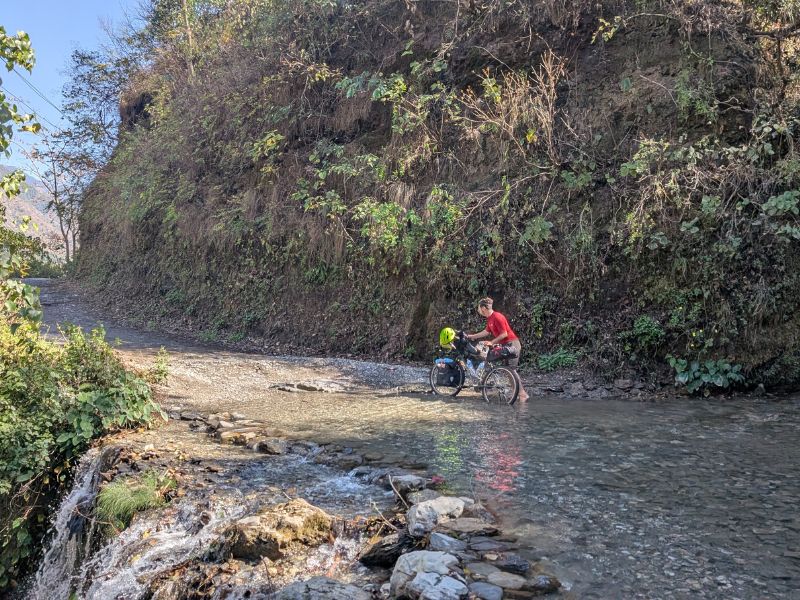
From Kagbeni, we take a dirt road along the river that leads us to the small village of Tiri. A few houses, a tea house, a monastery, and apple orchards, the specialty of this area.
Tiri is the last village before the imaginary border that separates us from the permit required to visit Upper Mustang.
We continue along the dirt road to the village of Sangda, which would take about 3 days to reach, plus food and camping gear, as there seems to be nothing along the way. It’s also possible to get there by motorcycle in 3 or 4 hours.
For today, we’ll take a walk of about ten kilometers, aiming to reach Terri Lake, at an altitude of around 3500 meters, and then return to Kagbeni.
We start early, but by 10 AM, the wind picks up strongly and blows against us. Here, it always blows from the south and stirs up dust storms.
Kagbeni to Jarkhot
Between pedaling (Daniele) and pushing (me), we cover the 10 km to the beautiful village of Jarkhot.
The road is perfectly paved with an average 10% incline. Traffic isn’t too bad, though there’s no shortage of pilgrim buses heading to Mukhtinat.
We’ll take an alternative trail downhill. For now, we enjoy the Jarkhot homestay.
The family is plowing the fields with the help of a man and his two yaks, to whom he sings a song every time they need to turn.
We don’t know if they’d turn without the song, but it’s a beautiful thing to watch.
In the evening, we eat in the family’s kitchen. They also offer us some local liquor made from fermented millet.
Muktinath
Arrival in Muktinath, lots of concrete buildings seem to have rained down randomly from the sky. We go visit the statue of Guru Rinpoche, at about 3,700 meters, with a beautiful view of the Thorong La Pass and the valley below us.
We descend and then climb the steps leading to the Hindu temple and the Buddhist monasteries.
For Buddhists, it is considered one of the 24 most important tantric sites, and is where Guru Rinpoche, also known as Padmasambhava, meditated and attained enlightenment. For Hindus, it is a place where Lord Vishnu is believed to have been granted liberation.
Many Hindus have arrived here by car, and as we’ve seen many times, lots of people are overweight and can’t manage to take ten steps.
But here, there’s a solution — they get carried from the parking lot to the top of the stairs by four porters with a palanquin.
A shameful sight. Especially when we see people young enough to walk up on their own. So what’s the point of a pilgrimage then?
At the entrance, we head toward a small Buddhist temple where a nun is singing and playing. It’s just us there.
We continue up the steps and visit the beautiful Buddha statue and the monastery where a natural flame is always burning. Everything is clean and well-maintained.
Passing through the Hindu area, there’s trash everywhere — it seems the caretakers can’t keep up with collecting and burning it. Empty oil bottles, dozens of instant noodle wrappers, cans, and random plastics. We should be used to it by now, and yet we keep asking ourselves why.
A few more steps and we’re back in the peace of the Buddhist nuns. Again, it’s just us and a couple of other pairs. One nun is playing music while another prepares herbs as water boils in the solar cooker in the middle of the courtyard.
Muktinath to Marpha
From Mukhtinath, we have two options to descend towards Jomsom without taking the paved road.
One trail goes through the small village of Lupra and comes out between Kagbeni and Jomsom, while the other passes near the village of Jhong and leads to Kagbeni.
A shop renting mountain bikes in Mukhtinath tells us that with our bikes—no suspension and with bags—we can forget the trail to Lupra.
We take the trail that goes through Jhong—a beautiful road, but the wind is so strong we have to pedal in the lowest gear even downhill.
Here we might spot some Blue Sheep (which we had seen in Ladakh, on the Tanglang La Pass) and the Snow Leopard.
We don’t spot them, but we do come across a very charming village and some hikers heading down.
Once we hit the asphalt, the wind doesn’t die down at all.
We pass through Jomsom, where the dirt road (or “bombed road”) to Marpha begins—a place a couple we met in Jarkhot recommended.
We arrive dusty and exhausted from the wind, even though we’ve officially descended 1000 meters.
A quick stroll around the village, and tomorrow we continue descending.
Marpha is a strange village (we mean “strange” as a compliment). As soon as we entered the town, the wind completely disappeared, which is really pleasant.
We find a guest house for 1000 rupees (€7), which is the “official” price pretty much everywhere on the Annapurna circuit. Half the price if the bathroom is shared.
In some cases, the room is free because the profit comes from the quadrupled restaurant prices.
As I was saying, Marpha is strange. It’s called the Apple Capital of Nepal, and indeed, the dried apples and apple pies here are delicious.
It seems that most people working in the village are descendants of Tibetan refugees from the refugee camp across the river.
The main business, besides hospitality, seems to be renting traditional clothes to local tourists, who then dress up as Tibetans and film TikTok videos in the village alleys.
The main street is called TikTok Road — the town feels like a TikTok set, which, from what we understand, is very popular in Nepal. We’ve seen signs saying “TikTok forbidden” almost everywhere, especially on bridges or other potentially dangerous spots.
Besides TikTok, there’s a beautiful temple in the center of town. Apparently, residents are required to maintain the white color of their dry-stone walls and houses.
The white paint is made from a mixture of lime and natural minerals that has been used for generations.
Every home has an inner courtyard, a tradition we also saw in Ladakh and Himachal Pradesh. These courtyards are cozy, offer privacy, and protect from dust.
Marpha to Beni
From Marpha, the road gets better, but the strong headwind doesn’t leave us.
We can see part of the trail on the other side of the river, walkable by foot, though most hikers stay on the road.
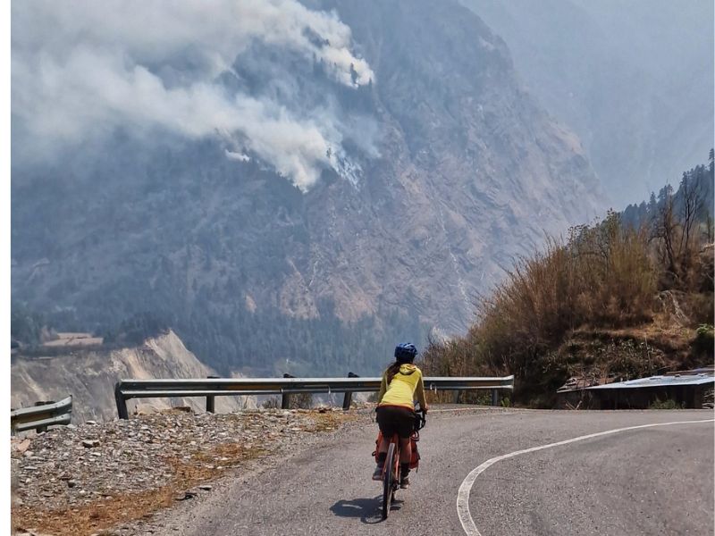
Today, the pollution is off the charts—thick fog and a burning smell due to forest fires everywhere.
Even in Marpha, at 2500 meters, we see massive flames. Breathing is hard.
After Gasa, the landscape becomes more beautiful, and we ride through a nice gorge.
However, poor visibility and the smell kill the mood.
We pass through Tatopani, known for its hot springs, but the high temperature pushes us to keep going.
We ride past Beni, and instead of sulfuric water, we enjoy a cool pool and a cold beer.
It feels like summer again. Tomorrow we head back to Pokhara, hoping to leave the bikes and hike Mardi Himal.
Still unsure if visibility will be good or not.
The fires are everywhere—we count about ten, and those are just the visible ones.
The road from Beni to the one leading to Pokhara is terrible: sand, traffic, dust.
We met other cyclists for the first time: two New Zealand girls on full-suspension bikes who will try to climb Thorong La carrying their bikes on their shoulders—from the “wrong” side.
And a Japanese guy with the “wrong” bike for this road.
The road to Pokhara is mostly paved, but because of the smoke and pollution, you can’t see a thing.
We sense it might be a nice road—it climbs up to about 1800 meters, and from there the Mardi Himal trail starts. Sadly, you still can’t see anything, so it would be a wasted hike.
Honestly, we didn’t expect Nepal to be this polluted. Around September, after the rains, it should be much better.
We arrive in Pokhara and enjoy one last dystopian sunset over the lake.
Kathmandu
The bus ride from Pokhara to Kathmandu takes about 10 hours to cover less than 200 km. A “Deluxe” bus ticket costs around €8 per person, bikes included. Comfort is basic: no reading, no sleeping, just hours of bouncing in your seat.
The road follows the river, passing rafting spots and several temples (some accessible by cable car). Still, it’s not a recommended cycling route—traffic, dust, and pollution make it unpleasant.
Kathmandu is notorious for its heavy pollution. Many travelers suggest skipping it, but spending a few days here is worthwhile. Big cities often concentrate art, history, and culture, offering insights into the country.
Expect:
- Scooter traffic and urban chaos outside the old town
- The Bagmati River, sacred yet sadly used as an open sewer
- Narrow alleys, beautifully carved wooden windows, quiet courtyards with Shiva lingams
- Good local food and authentic atmosphere
After days of thick smog (at times Kathmandu tops the list of the world’s most polluted cities), rain can clear the skies and even reveal the outline of snowy Himalayan peaks.