Skip the overpriced tourist trail. Our complete Tanzania self-drive guide covers every region of the country with real costs, honest park reviews, and accommodation for every budget.
Tanzania is one of the most diverse countries in East Africa – with a wild, endless coastline, vast plains and forested mountain plateaus, three of the largest lakes on the continent, and two of its highest peaks. And I haven’t even mentioned the three stunning tropical islands yet.
Unfortunately, most tourism in the country is concentrated around just three hotspots: Zanzibar, Kilimanjaro, and the Serengeti/Ngorongoro national parks.
Disclosure: Some of our articles contain affiliate links. This comes at no additional cost for you and helps us keep this website up and running. (as Amazon Associates we earn commission from qualifying purchases)

As often happens, tourist hotspots mean overpriced services and a higher risk of scams, and in these areas of Tanzania, both are definitely on another level… but we’ll talk about that later.
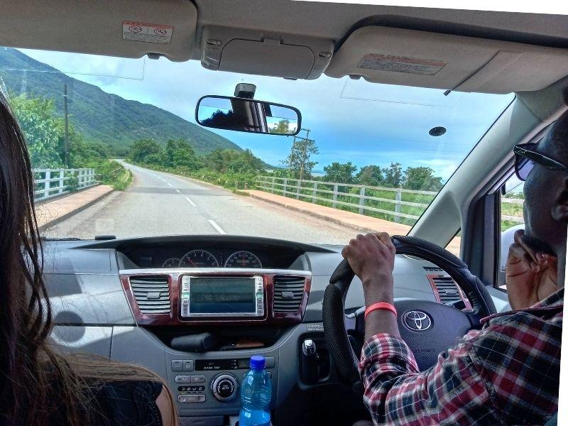
Tanzania really is an excellent self-drive destination, especially if you stay off the beaten path, where everything offers better value, and people are friendlier.
Before giving you detailed information about the route we followed, let’s try to answer some of the most frequently asked questions about self-driving in Tanzania:
- Yes, Tanzania is safe.
- Mechanics are literally everywhere, and we ended up visiting them quite often.
- The roads are generally well-maintained.
- Police checkpoints are everywhere. The speed limit is often 50 km/h, and the fine for any traffic violation is around €30, although it’s usually possible to negotiate.
- Places to stay can be found almost everywhere. Apart from inside the national parks, you don’t need to book in advance. It’s better to show up in person and check that there is a safe place to park your vehicle.
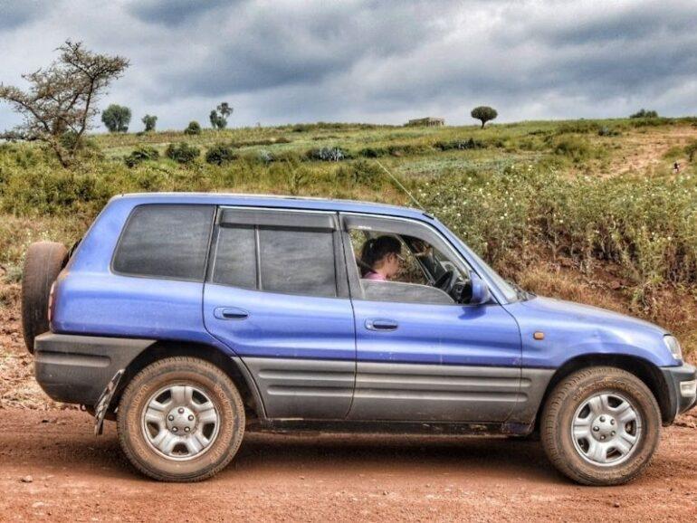
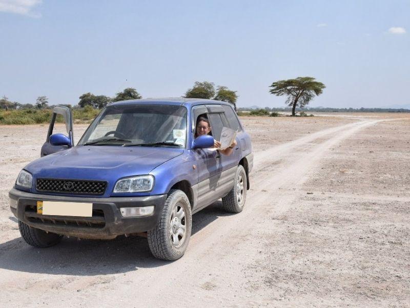
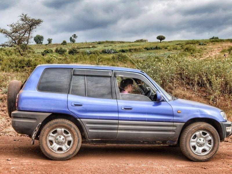
- Self-driving is allowed in all national parks. A Toyota RAV4 is sufficient for most of them. For the Serengeti, however, you will need a Hilux or a Defender. Naturally, if you’re travelling during the rainy season, you’ll need to consider carefully whether it’s worth it.
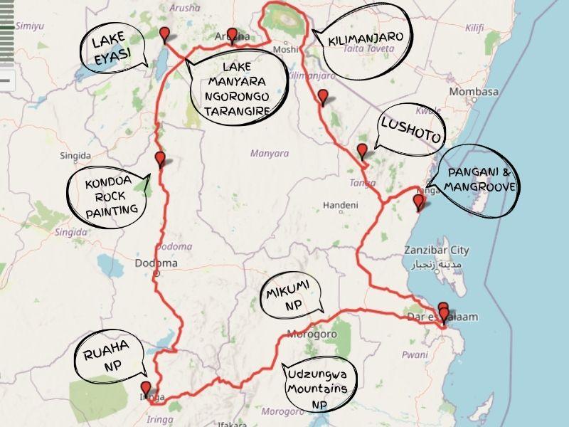
Our self-drive in Tanzania on Google Maps
This itinerary starts in Dar es Salaam, but since it forms a loop, you can begin wherever you prefer.
Bagamoyo, Pangani, and Tanga – History and Mangroves
If you’re starting from Dar es Salaam, be prepared to face heavy traffic at the beginning of your journey. Once you leave the city behind, things become much more relaxed. Tanzania is a huge country, and most of its population lives along the coast.
Going north, this coastal stretch is one of Tanzania’s most rewarding and least-trodden routes, and the perfect antidote to Zanzibar if you want history, beaches, and zero tourist circus.
Bagamoyo is the starting point coming north from Dar, and it punches well above its weight historically. The old town is a UNESCO World Heritage Site — stroll down its narrow streets lined with 19th-century Arab-influenced buildings, visit the Old Fort, once used as a colonial prison, and the Kaole Ruins just outside town, which date back to the 13th century and include the remains of mosques and tombs from a thriving Swahili civilization.
The dark side of the town’s past is inescapable, too: Bagamoyo was the last stop before enslaved people were shipped to Zanzibar, and the Slave Port and Caravan Serai are sobering but essential sites.
Don’t miss the Bagamoyo College of Arts — live traditional dance performances happen here regularly, and it’s worth timing your visit around one. The beach south of town is quiet and uncrowded. If you just want Zanzibar-quality sand without Zanzibar prices or crowds, this is it.
Heading north, the coastal road takes you to Pangani, which is probably the single most underrated beach destination on the Tanzanian mainland. Still largely overlooked by most travelers, it sits about 50km south of Tanga, where the Pangani River meets the Indian Ocean. It became an important caravan trading post in the 19th century, and you can still feel that Swahili-Arab history in the carved doorways and colonial-era buildings scattered around town.
The beaches north and south of the river — Kigombe and Ushongo Bay, respectively — are exceptional. Boutique eco-lodges sit directly on the beach among palm trees, and the whole area has a refreshingly intimate atmosphere. Maziwe Island, just offshore, is a marine reserve with great snorkeling and, if you’re lucky, nesting turtles. Kayaking, dhow rides, and deep-sea fishing are all available through the lodges.
Getting across the Pangani River requires a small ferry — it’s a bit of an adventure and adds to the charm.
Where we stayed around Pangani: Bahari Poti Resort Pangani
Tanga is the last stop before the Kenyan border, and it’s an honest, slow-moving port city that most overlanders just pass through — which is exactly what makes it worth a night. It’s a quiet, historic Swahili coastal town where you can stroll through old streets, eat great fresh seafood, and relax by the mangroves without a single tout in sight. The market near the waterfront is excellent for produce and street food.
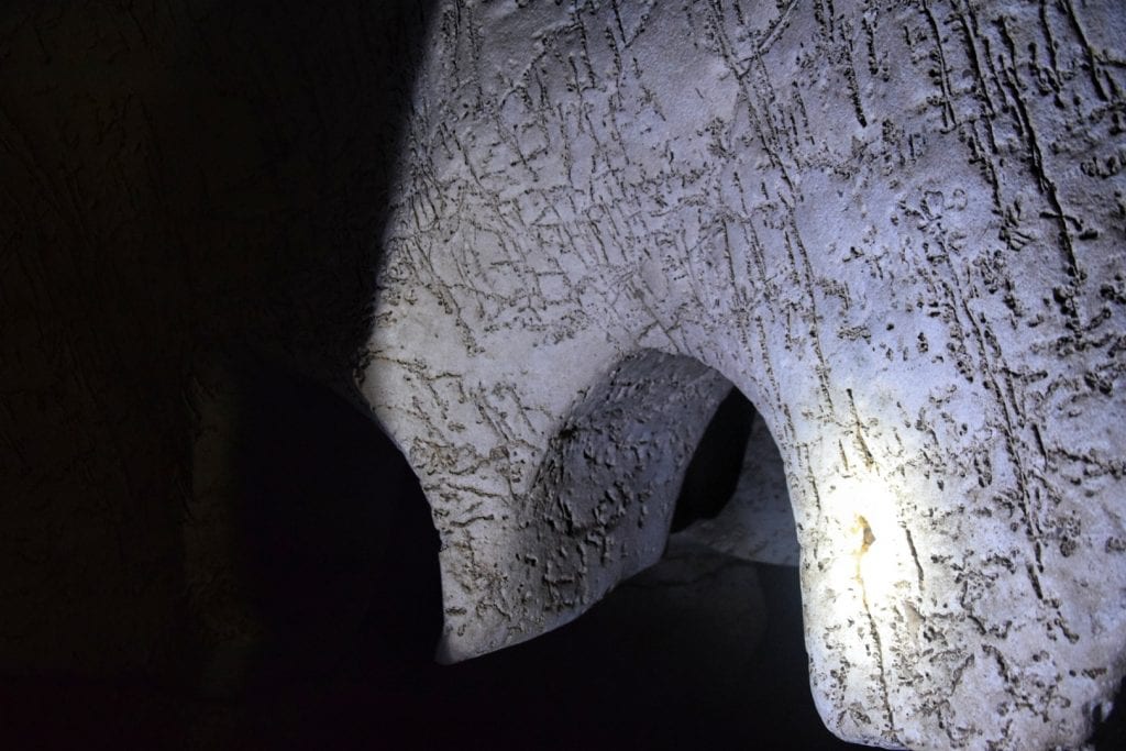
Around Tanga, you can visit the Amboni Cave. We wrote a full guide that you can read here.
Where to stay in Tanga: Ocean Breeze Hotel (30.000 for an AC room)
Mkomazi National Park and the Mountains of Lushoto
About 3 hours from Tanga, you’ll reach Lushoto — and the road that climbs up from the junction at Mombo is absolutely stunning. It’s narrow, though, so be careful if you’re driving something big: you will meet buses both coming up and going down, and they will announce themselves on every bend with their horns.
The Usambara Mountains are considered a biodiversity hotspot thanks to a remarkable degree of endemism in both flora and fauna — this mountain range formed millions of years ago and has remained relatively undisturbed, which has allowed ancient forests and extraordinary ecosystems to develop. The whole area feels like another Tanzania entirely — green, cool, unhurried, and completely off the mass tourism radar.
Lushoto itself is a small, genuinely charming highland town that was a German colonial hill station; the cool mountain climate is a genuine relief after the coast, and the landscape is a patchwork of lush farmland, forest, and flowering hillsides.
The main reason people come here is hiking; the Usambaras offer amazing views and a network of trails ranging from a couple of hours to multi-day treks of up to 8 days.
The signature hike is up to Irente Viewpoint — a 15km round trip that ends at a jaw-dropping outlook over the village of Mazinde and the Maasai plains almost 1,000 meters below, with lunch at the Irente Biodiversity Farm in their beautiful flower garden.
For the more adventurous, the multi-day trek from Lushoto to Mtae covers 82 kilometers through villages, forests, clifftops, and valleys — one of the best long-distance walks in East Africa that barely anyone knows about.
Where we stayed in Lushoto: Lawns Hotel
Mkomazi National Park
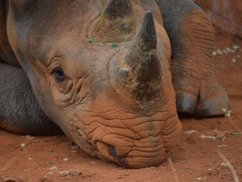
On the way down from Lushoto towards Same and the road south, Mkomazi is one of those parks that road trippers keep almost accidentally skipping — and really shouldn’t. We’ve been to almost every park in Tanzania, and Mkomazi is genuinely special: the landscape is completely different from anywhere else in the country, and it’s the only park where you’re pretty much guaranteed to see both rhinos and wild dogs.
Inside the park, there’s a fenced conservation area housing a dedicated rhino sanctuary — and this is where it gets interesting. You can’t enter with your own car, nor with a standard safari vehicle. A park ranger picks you up in their own 4WD and takes you in.
The experience was fantastic: unlike safari cars, the rangers can drive wherever they need to — if they spot a rhino in the distance, they don’t hesitate to leave the track and push straight through the bush off-road to get you closer. It felt more like a proper wildlife encounter than anything we’d experienced in a conventional game drive.
We stayed in the park bandas, and they were a genuine surprise — air-conditioned, spotlessly clean, and there’s even wifi in the common area by the kitchen.
Around the Kilimanjaro, Masaai NP, Arusha, and Hot Springs
The road that loops around the base of Kilimanjaro — going west from Himo to Arusha — is a revelation. The drive takes you through Chagga village life in the densely cultivated green foothills: banana groves, coffee plantations, neat homesteads, and the constant presence of the world’s largest freestanding mountain looming above it all.
On a clear morning, the summit is visible, glaciers catching the light. By mid-morning, the clouds usually move in and wrap it up, so get going early.
The road passes through small villages like Sanya Juu and Ngare Nanyuki on the northern, drier side — the landscape shifts dramatically as you come around the back of the mountain, from lush green farmland to open, semi-arid acacia savannah with big skies and occasional Maasai herders. The contrast within just a few kilometers is genuinely surprising. After Ngare Nanyuki, the road turns to gravel in places.
Where we stayed: Simba Farm
Enduimet Wildlife Management Area (WMA)
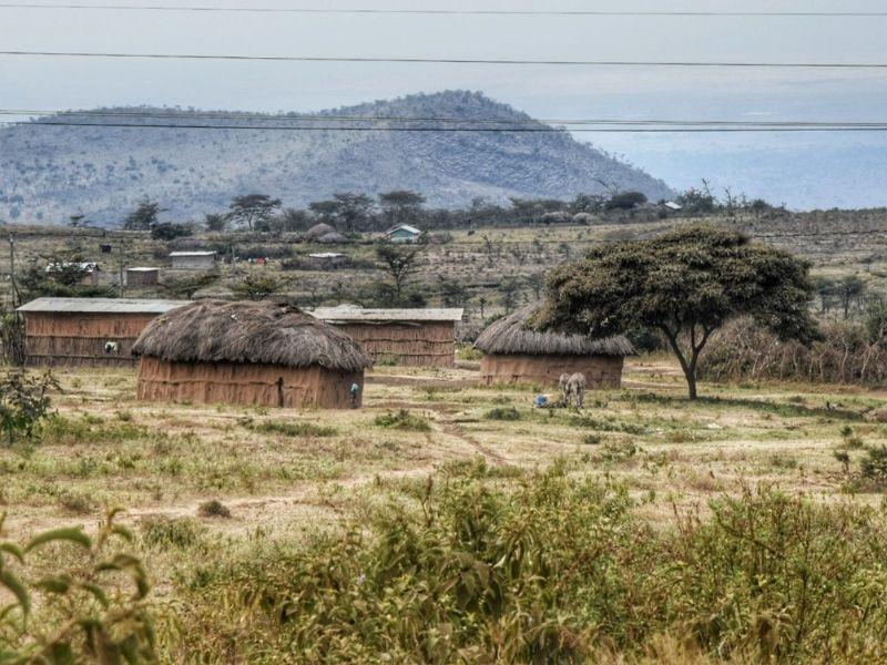
Enduimet Wildlife Management Area (WMA) on the western side of the mountain is the hidden gem of this whole loop — and one of the most underrated wildlife areas in Tanzania, full stop. Founded in 2003 with nine villages in the West Kilimanjaro Basin, it’s a community-based conservation area where Maasai herders benefit directly from tourism.
It’s a quiet success story protecting the vital wildlife corridors of West Kilimanjaro, including the Kitenden Corridor, an elephant “highway” linking Tanzania to Kenya’s Amboseli. Wildlife includes elephants, giraffes, buffalo, leopards, oryx, wildebeest, hyenas, and various gazelles. And people…you can see people and shepherds walking and living inside the park.
The best part for road trippers: unlike most Tanzanian parks, you can explore Enduimet with a regular car. We were only asked for the international driving licence at the gate. Walking safaris with a Maasai ranger are available.
Lake Chala is the unmissable stop on the eastern side of the circuit, right near the Kenyan border town of Taveta. It’s a dramatic water-filled volcanic caldera on the southeastern flank of Kilimanjaro, with steep forested crater walls dropping almost 100 meters to the water below. The lake is fed entirely by underground springs from Kilimanjaro’s glaciers. You can kayak on the lake, hike the crater rim, or sit at the viewpoint and stare.
Arusha
On the way to Arusha, you’ll find the Kikuletwa Hot Springs (Chemka): a series of warm, crystal-clear pools deep enough to dive into but so transparent you can see every detail of the bottom. The drive from the main road winds through dry riverbeds, baobabs, and acacia trees, with Maasai herding cattle along the way. The last section is unpaved and bumpy, but passable in a regular car during the dry season. There’s a rope swing, baboons in the trees overhead, and vendors selling coconuts and chips mayai at the entrance. Avoid the weekends.
Arusha is hectic, overpriced, and swarming with safari touts — all the things the rest of Tanzania largely isn’t. That said, it has the best restaurant scene in northern Tanzania, reliable ATMs, mechanics, and spare parts if you need them before heading further. Also, visit the Cultural Heritage Centre, one of the most complete and beautiful African mask museums we have seen (there aren’t many) and probably the best place to buy art and souvenirs.
Mto wa Mbo: Lake Manyara, Tarangire + Ngorongoro
Mto wa Mbu is the gateway village for organising safaris to the many parks in the area. The most famous is Lake Manyara, known above all for its tree-climbing lions — a genuinely unusual behaviour that still puzzles researchers.
We’ll be honest, though: the paid section of the park didn’t blow us away. Partly because we were driving a dark blue car with tinted windows, which turned out to be essentially a tsetse fly magnet. There were hundreds of them. Relentless.
We did spot some elephants and buffalo, but the vegetation inside Manyara is extremely dense, and we didn’t have much luck.
What we absolutely loved, though, was the free area outside the park — the lakeshore zone you can explore on foot or by bike, wandering between Maasai villages, local fishermen, and enormous marabou storks stalking the shallows. No entry fee, no tsetse flies, no other tourists. It felt like the real lake. You can read more about it here.
Tarangire has the highest concentration of wildlife of any Tanzanian national park after the Serengeti — and in terms of elephants specifically, it’s arguably the best place on the entire continent. Tarangire is considerably more affordable than the Serengeti — park fees are lower, camps offer better value per dollar, and the drives from Arusha are shorter. For a self drive Tanzania, it’s also one of the more forgiving parks: the main circuit road along the river is well-maintained, and the wildlife concentration means you don’t have to go far to find something.
Best time: Animal concentration peaks between July and the start of the rains in November. From November to May, much of the game disperses out of the park entirely. We have friends who visited in February, and they still saw a lot of animals, tho.
Ngorongoro is one of the most spectacular places on earth, and we were so lucky the first time we visited during Covid; we were the only car in there. Otherwise, prepare for a long queue and a crowded experience, not the kind os safari we like. Descending 2,000 feet into an ancient volcanic caldera where 25,000 animals roam freely across a 100-square-mile natural amphitheater. Authorities require all self-driving visitors to be accompanied by a park ranger inside the crater. This is arranged at the gate and costs around $40, payable in cash only.
Lake Eyasi
Lake Eyasi is a really off-the-beaten-track landmark in Tanzania. Although located in the most visited region of the country, bordering Ngorongoro Conservation Area and pretty close to Lake Manyara, this fascinating place is rarely visited, if not by those interested in visiting the Hadzabe “bushmen” community.
The size of Lake Eyasi varies greatly with the seasons – while almost nonexistent at the peak of the dry season, it often floods nearby settlements when the rainy season is heavier than normal (which is happening more and more often).
Although some maps show three ways to reach Lake Eyasi, only one of those is actually viable, at least according to the many locals we asked.
The two alternatives, one leading to Mbulu and the other one going along the Lake to the road Singida-Mwaza, might probably be tackled by real adventure seekers with the proper vehicles.
Expert bicycle tourists or motorbike travelers might make it in the dry season, while the paths might be too narrow for a car.
About 8km from Mangola, there’s a tourist office where you’re supposed to register and pay a $20 fee per car. If you are planning to engage in any cultural activity, which usually means a visit to the local Hadza tribe, the fee skyrockets to a steep 110$ per car.
What we’ve understood from talking with locals is that this fee should only be paid if you plan to stay overnight on Lake Shore.
The fee allegedly goes to the community, but we hardly believe that, given the conditions in which the local communities live – among the poorest we’ve seen in Tanzania (and not just the Hazda, who basically don’t know money).
Read our complete guide to Lake Eyasi here.
The Road to Dodoma
The road is very interesting, wild, and varied until Kondoa (stop for the rock paintings) and even a bit further.
The landscape between Tarangire NP and Lake Manyara is really unique and worth a deeper exploration.
Getting to the noisy and somehow alcoholic town of Babati, it turns green again, with banana plantations and roadside nurseries.
Lake Babati is a nice stopover, with its large population of hippos, before tackling the beautifully forested hills towards Kondoa — an area that reminded us of Lushoto.
A nice stop in Kondoa, read our full guide here.
Shortly after Kondoe, the road becomes flatter and lined by dry bush all the way to Dodoma. Baobab trees, succulents, and megaliths.
Dodoma is Tanzania’s official capital — moved here from Dar es Salaam in the 1970s as part of a political decentralisation project that never quite finished. It shows. The city has the slightly unfinished, bureaucratic feel of a capital that exists more on paper than in practice, and there’s honestly not much here.
One practical warning: hotels can be surprisingly hard to find or fully booked — government workers and parliament sessions soak up a lot of the limited accommodation. If you’re arriving late in the day, book ahead.
Driving from Dodoma to Iringa
From Dodoma to Iringa is 250 more dry kilometers, probably one of the highest concentrations of baobab trees in the whole Africa. A few tiny villages where to get water, cookies, and grapes(!), and no petrol station for the whole stretch (we saw one under construction).
Iringa is our favorite city in Tanzania; it’s the only place where no one ever called us muzungu in our whole Southern and East Africa trip. It’s a cozy town, populated by 1,200,000 people, a variegated mix of Hindus, Sikhs, Muslims, and Christians of all kinds of faiths.
This interesting city lies somehow in the middle of Tanzania, on the main country’s traffic artery (connecting the south with Dodoma and Dar Es Salam. Situated 1,600 meters above sea level, the sun can be striking during summer, but temperatures get very low for this latitude in winter nights.
The laid-back vibe of the city really makes it worth spending some days exploring around. There are quite a few attractions to see in and around town, and a bunch of interesting activities to be involved with. Iringa is also the base to explore our favorite Tanzanian National Park, Ruaha.
Visit the Iringa Boma Museum, where you can learn about the history of Iringa, especially the focus on the epic battle that saw the defeat of the Germans at the hands of the Hehe People, led by Chief Mkwawa. You’ll also learn something about local witch doctors’ practices and the process of Christianization of the population.
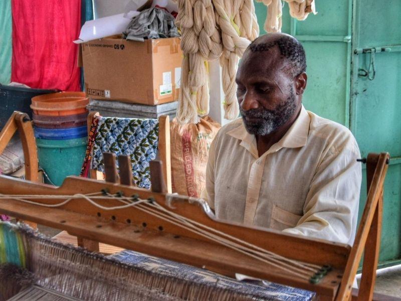
Another interesting place to visit is Neema Crafts, a Christian organization working to empower deaf people. They have a small factory where they produce beautiful crafts. It’s possible to visit the factory and see the traditional looms in action, and other interesting crafting techniques. They also offer accommodation.
Around Iringa, you can visit the Isimila Stone Age Site. This unique landscape of eroded sandstone pillars has been the theater of one of the most important Stone Age archeological finds ever. The small museum displays some of these old tools and explains the importance of the finding. Read our Isimila guide.
Ruaha National Park
This is our favorite national park in Tanzania, together with Mkomazi, and honestly, one of our favorites in all of Africa. While everyone rushes to the Serengeti, Ruaha sits there, vast and almost forgotten, doing absolutely everything better. No crowds.
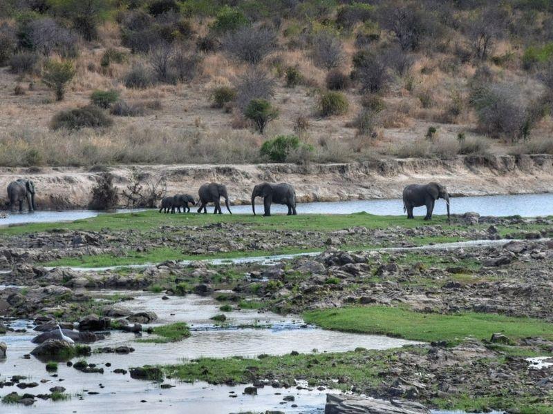
Unbelievable wildlife density. Enormous herds of elephants — we’re talking 50, 100 at a time — lions, leopards, wild dogs (rare!), hippos, crocs, and more than 570 bird species. The landscape is stunning: endless miombo woodland, open plains, rocky outcrops, and the Great Ruaha River cutting through it all. The baobabs here deserve a mention of their own.
At over 20,000 km², it’s the largest protected area in Tanzania. The park sits about 130km west of Iringa — a rough but beautiful drive — and the remoteness is a big part of the charm.
Best time to go: Dry season, June to October, is when wildlife viewing is at its peak, as animals cluster around shrinking water sources. For birds, the European winter months (December to April) bring migratory species south. Note that some lodges close during the long wet season (March–May).
Entry fees: Non-resident adults pay around $30/day (low season) or $50/day (high season). Children aged 5–15 pay $10–20/day. Vehicle entry fees vary — roughly $10/day for smaller vehicles, $20/day for a Land Cruiser (locally registered). Public campsites cost around $35/person/night; special campsites (secluded, no facilities) run about $59/person/night. Fees are set by TANAPA and change frequently — always verify before going.
Self-driving: Entirely possible if you have a 4WD, especially in the dry season. The park tracks are rough, and signs are minimal, so a GPS map downloaded offline (Maps.me or similar) is essential.
Where to stay in Ruaha: We slept in the bandas inside the park. You can also camp there, but I personally do not like unfenced camping in a park full of lions.
Iringa to Morogoro
Down from Iringa on the only road, winding and full of speed bumpers, to the main crossroad, south to Mbeya/East to Dar es Salam, good tar and countryside scenery for the first 40km.
The beautiful grassland at Lugalo (keep your eyes open and you’ll spot plenty of birds) is the prelude for the first real downhill, where you first meet the Ruaha river towards Mbuyuni, and be ready for a steep and gorgeous descent through the river gorge. Watch out for baboons.
Uzungwa Mountains NP
Mbuyuni is at the beginning of the Uzungwa Mountains NP, here there are a few guesthouses, or the nice Crocodile Camp (a bit run down), 15km further. This is a beautiful area worth spending some time hiking or on a boat trip (these can be arranged through the Crocodile Camp or any tour company in Iringa).
Morogoro to Dar es Salaam
This is a long section of narrow highway with dense traffic of lorries. it mostly passes through the bush, with just a few villages – it’s outstanding to note how undeveloped this area of Tanzania is.
Although less than 200km, driving this road takes at least 4 hours.