
Cycling the Rallarvegen from Finse to Flåm: Norway’s most spectacular cycling route. Route guide, surface conditions, accommodation, practical tips, and GPX info.
There are routes you plan carefully, and there are routes that find you. The Rallarvegen found us somewhere between a soggy map and a conversation with a Norwegian cyclist at a campsite near Geilo, who said simply: “You have to do Finse to Flåm. There is nothing else like it.”
He was right. It is still one of the most beautiful roads we have cycled so far.
Disclosure: Some of our articles contain affiliate links. This comes at no additional cost for you and helps us keep this website up and running. (as Amazon Associates we earn commission from qualifying purchases)
The Rallarvegen — literally “the Navvies’ Road” — is the old construction track built between 1902 and 1909 to support workers building the Bergen Railway across the Hardangervidda plateau.
For a century, it sat quietly in the mountains, used occasionally by maintenance crews and adventurous hikers. Then cyclists discovered it, and now it is consistently ranked among the most spectacular cycling routes in Europe. It compresses the variety of Norway’s landscape into a single ride: snowfields, ridges, rivers, and waterfalls.
We rode the Finse to Flåm section — approximately 54 kilometres (34 miles) — over one long day. It is not a distance that should intimidate anyone. It is a route that should make you stop constantly, look around, and wonder how you got lucky enough to be here.
Read also our article: Cycling Norway – All you need to know to plan a bike trip to North Cape
The Route at a Glance
Start: Finse (1,222 m / 4,009 ft) — Norway’s highest railway station, accessible only by train
End: Flåm (sea level) — on the Aurlandsfjord
Distance: ~54 km / 34 miles
Elevation loss: ~1,220 m / 4,000 ft (net descent — but with some climbing)
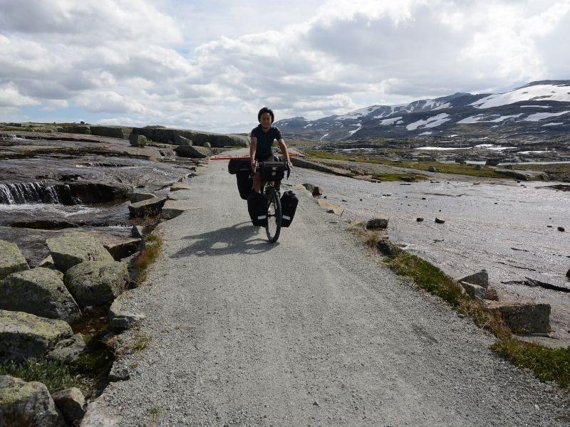
Surface: Mixed — compacted gravel and rocky track, with some sections of rough, uneven terrain requiring dismounting. The lower half (below Myrdal) is better surfaced
Direction: Always ride Finse → Flåm (top to bottom). Climbing from the north is significantly more difficult, and the views are better going downhill
Season: Mid-July to mid-September are the recommended dates, depending on weather and snow conditions. Check haugastol.no/en/rallarvegen-report before departure for current conditions
Difficulty: Demanding. There are several steep, narrow, and exposed sections. Along some stretches, dismounting and pushing is recommended. The tour is not suitable for children.
Best bike: Gravel bike or hardtail MTB with 40mm+ tyres. A loaded touring bike works, but makes the rocky sections harder. Road bikes are not suitable
GPX: Available at rallarvegen.com and on Komoot
Getting to Finse
Finse is only accessible by train — there are no roads. This is part of what makes it special. Take the Bergen Railway from either Oslo (approximately 4 hours) or Bergen (approximately 2.5 hours). Bikes are allowed on regional trains with a ticket — book in advance as spaces are limited, especially in July and August.
The train ride itself is extraordinary: the Bergen Railway crosses the Hardangervidda plateau at altitude, passing through some of the most dramatic mountain scenery in Europe. It is worth a window seat in either direction.
Where to Sleep in Finse
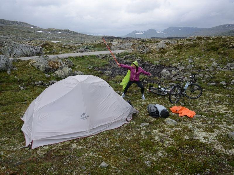
Finse is a tiny settlement — a train stop, two accommodation options, a couple of bike rental shops, and not much else. No supermarket, no petrol station, no village in the conventional sense. We camped because hotels in Norway are very expensive, plus you have a much more beautiful view from your tent.
Hotel Finse 1222 — the original railway hotel, built in 1909. The hotel was built as part of the Bergen Railway and has since been the gateway to Norway’s most beautiful and accessible mountain areas. Rooms are comfortable but not luxurious — the price (~$325/night) includes a three-course dinner, high-quality breakfast buffet, and a packed lunch for the road. The restaurant with glacier views makes up for the cost. Book well in advance for summer dates. A fun fact: The Empire Strikes Back was filmed in Finse, and actors and crew stayed at Hotel Finse 1222.
DNT Finsehytta — the Norwegian Trekking Association mountain lodge, approximately 300 metres from Finse station. A more affordable option with dormitory and private rooms, a restaurant, and a remarkable bonus: Europe’s highest brewery at 1,223 metres, brewing beer from clean mountain water. DNT membership gives a discount on accommodation throughout Norway and is worth getting if you plan to spend time in the mountains.
Stock up on supplies at Finse — the next reliable resupply point is Myrdal, some 36 kilometres away.
The Route — Finse to Flåm
Finse to Hallingskeid (~21 km)
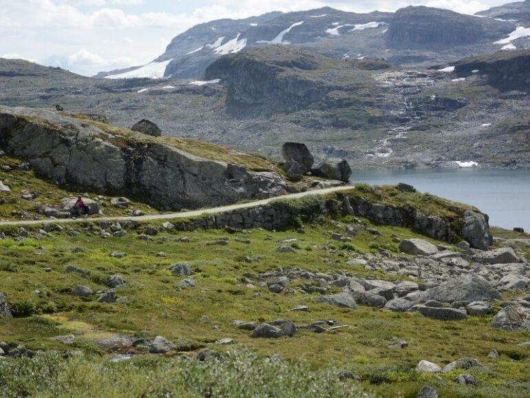
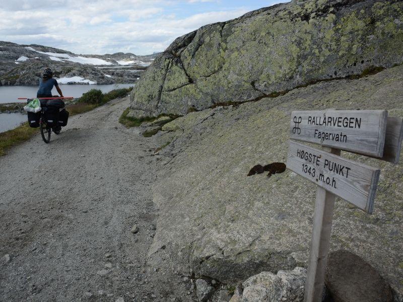
Leaving Finse, the route begins with a climb — counterintuitive for a route that ends at sea level, but the highest point on the Rallarvegen is not Finse itself but Lake Fagervatnet, at 1,343 metres, approximately 8 kilometres into the ride. From here, it is more or less downhill all the way to Flåm.
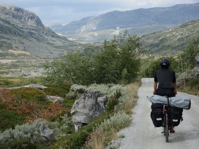
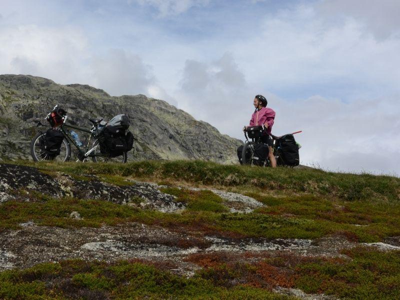
The first section crosses the Hardangervidda plateau — one of the largest mountain plateaus in Europe, and one of the most desolate landscapes you will find on a bicycle. As you approach the small settlement of Finse, Norway’s sixth-largest glacier, Hardangerjøkulen, comes into view. On clear days, it dominates the plateau, making it one of the true highlights of the ride. In summer, the glacier is accessible by guided tours departing from Finse — worth the detour if you have time.
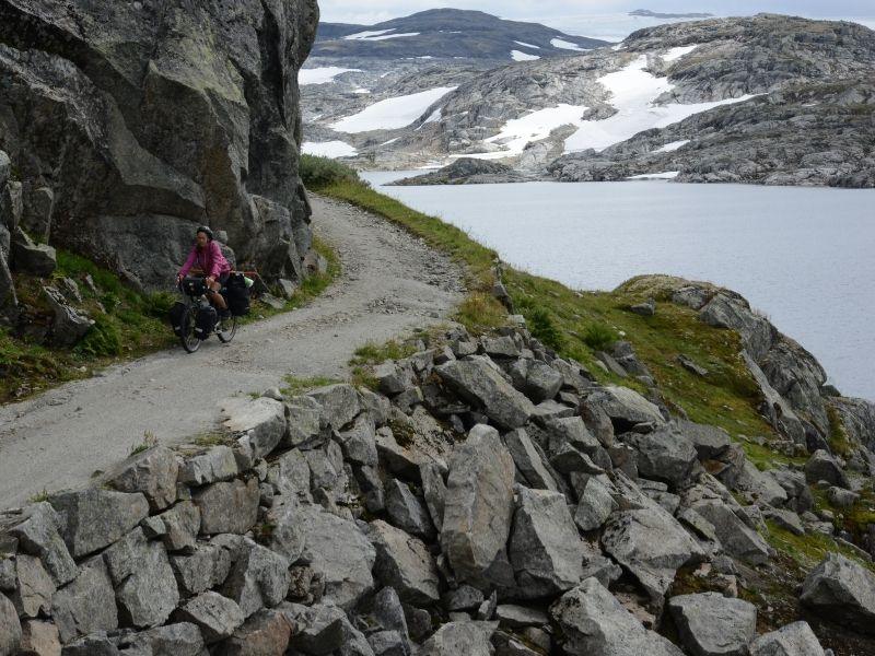
The section between Finse and Hallingskeid (11 km) has some rough, rocky, and uneven areas with a few short but steep descents. Inexperienced cyclists should take their time over this part. This is the section most likely to require dismounting, particularly if you are riding a fully loaded bike. The reward is complete solitude: once the gate closes to cars a few kilometres from Finse, you share the track only with other cyclists and the occasional reindeer.
Water is freely available throughout — mountain streams are clean and drinkable.
Hallingskeid station at 1,110 metres is located 21 km from Finse. There is a DNT self-service lodge here — staffed in season — where you can refill water, eat something, and take stock before the long descent begins. This is also where the train stops, which means it is a possible bail-out point if the weather deteriorates.
Hallingskeid to Myrdal (~15 km)
This is where the Rallarvegen begins to earn its reputation. From Hallingskeid, the road gradually descends through fantastic West Norwegian countryside with many waterfalls. The track follows the Bjoreia river canyon, threading between waterfalls and rock walls, occasionally running along narrow ledges above the gorge. Be careful at Klevagjeldet — the track follows a narrow mountain ledge with nothing to stop you plunging into the river below. This is not the place for distraction.
The Storurdi guard’s house appears roughly halfway down this section — a red wooden building offering refreshments and simple accommodation, still staffed in season. The old guard’s houses along the route are listed buildings, and all carry plaques showing the year in which they were built, part of the Rallarvegen’s designation as a cultural monument and part of Norway’s national heritage.
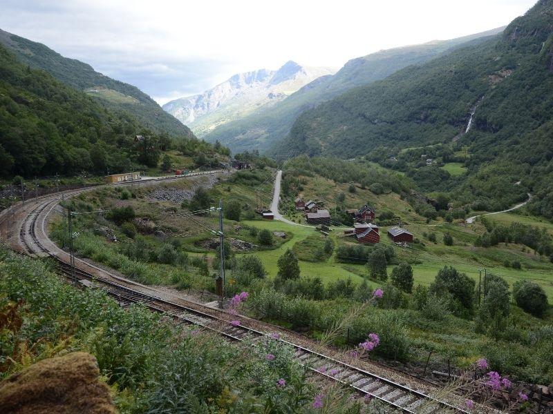
The descent towards Myrdal, where water has cut a deep path through the rocks, sees the track criss-crossing on wooden bridges over the sound of roaring water below. It is one of the most dramatic sections of cycling we have experienced anywhere.
At Vatnahalsen (812 m), a hotel perched above the valley offers coffee and food — a welcome stop before the final drop into Myrdal. From here, a short series of steep bends brings you down to Myrdal station.
Myrdal is a junction point and a decision point. The Flåm Railway — one of the steepest standard-gauge railways in the world, falling 865 metres over the length of the Flåm Valley — departs from Myrdal down to Flåm. If the weather closes in or legs give out, you can take the train from here. Café Rallaren at Myrdal station has food, coffee, and a bike service point on the platform.
Important: at Myrdal, the Bergen Railway enters the Gravhalsen Tunnel — more than 5 kilometres underground. There is no simple route for a cyclist around this one. If you are continuing toward Bergen or Voss by bike rather than descending to Flåm, you must take the train one stop to Upsete (Myrdal → Upsete, check schedules at nsb.no) and continue cycling from there through Raundalen toward Voss.
Myrdal to Flåm (~18 km)
The final section into Flåm is the most dramatic descent of the route. The final 20 km go through Flåmsdalen, a valley famous for its beauty. The track drops steeply through a series of hairpin bends, past waterfalls that fall hundreds of metres directly onto the road, past ancient farms clinging improbably to vertical valley sides.
Keep speed in check on this section — the Vatnahalsen–Flåm section has good conditions, but as always, there are very steep sections. Wear a helmet and keep your speed down.
Partway down the valley, a spectacular optional detour presents itself: the Flåm Zipline — Scandinavia’s longest zipline at 1,381 metres, reaching speeds of up to 100 km/h and dropping 305 metres through the Flåm Valley. It runs daily in season (NOK 850 adults / NOK 600 under-15s).
The tarmac begins a few kilometres above Flåm, and suddenly the world shifts: from mountain wilderness to fjord tourism in the space of a few bends. Flåm itself is a small village at the head of the Aurlandsfjord — one of the innermost branches of the Sognefjord, the longest fjord in Europe. It is busy with tourists in summer, but after a day on the Rallarvegen, you have earned the right to a meal with a fjord view and not feel guilty about it.
Practical Information
Bike Rental
If you do not have your own bike, rental is available at multiple points along the route. Flåm Bike Rental opens May 2, Haugastøl opens June 22 (with rentals on request from approx. June 10), and Finse opens July 3. Bikes can generally be rented at one end and returned at the other — ask at each rental point for current one-way options.
Luggage Transfer
Luggage can, if desired, be sent between the train stations at Haugastøl, Finse, Myrdal and Flåm — a useful option if you want to ride light without fully committing to bikepacking. Arrange this in advance through the Haugastøl tourist centre.
Snow and Conditions
The plateau above Finse can hold snow well into July in a heavy year. Early in the season, the full route may not be passable; during this period, taking the cycle on the train from Finse to Hallingskeid is advised. Check the live conditions report at haugastol.no/en/rallarvegen-report before departure.
Water
Mountain water throughout the route is clean and drinkable directly from streams. Carry at least one litre capacity, but you will rarely need to go more than 10 kilometres without passing running water.
What to Do in Flåm
Flåm is a logistical challenge for cyclists continuing by bike. There is a 12-kilometre bike-free tunnel immediately after the village. Options for continuing:
- Ferry to Gudvangen — crosses the Nærøyfjord (UNESCO World Heritage), one of the most beautiful short fjord crossings in Norway
- Ferry to Aurlandsvangen — shorter crossing, connects to road cycling routes south
- Public bus through the tunnel (approximately NOK 100)
The ferry to Kaupanger via Gudvangen is the most scenic option — a real cruise, lasting 2.5 hours. The most beautiful part is the initial section where the fjord is narrower and the mountains steeper. If you are lucky, you can also see seals.
Camping
Wild camping is a legal right in Norway (Allemannsretten) — you may camp anywhere on uncultivated land as long as you are at least 150 metres from the nearest house or cabin and stay no more than two nights in the same spot. On the Rallarvegen plateau above Finse, there are ample spots beside the route. Below Hallingskeid, the terrain becomes steeper and camping spots rarer — most people push through to Flåm in a single day.
Connecting Routes
The Rallarvegen fits naturally into a longer Norwegian cycling journey:
From Myrdal toward Voss: train one stop to Upsete, then cycle Raundalen to Voss — quieter and more scenic than the main road and the road below.
From Oslo to Finse: follow Road 7 along the Hallingdal valley via Gol, Geilo, and Haugastøl (approximately 300 km from Oslo). Haugastøl is the official start of the full Rallarvegen; you can begin riding from here rather than taking the train to Finse, adding 30 km of high plateau riding
From Flåm toward Bergen: ferry to Gudvangen, then road to Voss (Fv13), then south to Bergen — a spectacular route through Hardanger
After cycling North to Tromso, we kept cycling to Finland, from where we took the ferry to Estonia.